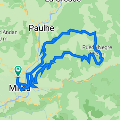
Rund um Millau
A cycling route starting in Millau, Occitanie, France.
Overview
About this route
A route where the highlight is a bridge. The Viaduct of Millau is included among others. Two climbs make the race interesting. The first climb goes from the riverbed up to the bridge and the second on the outskirts of Millau and not too far from the finish.
- -:--
- Duration
- 96.2 km
- Distance
- 1,076 m
- Ascent
- 1,076 m
- Descent
- ---
- Avg. speed
- ---
- Max. altitude
Continue with Bikemap
Use, edit, or download this cycling route
You would like to ride Rund um Millau or customize it for your own trip? Here is what you can do with this Bikemap route:
Free features
- Save this route as favorite or in collections
- Copy & plan your own version of this route
- Split it into stages to create a multi-day tour
- Sync your route with Garmin or Wahoo
Premium features
Free trial for 3 days, or one-time payment. More about Bikemap Premium.
- Navigate this route on iOS & Android
- Export a GPX / KML file of this route
- Create your custom printout (try it for free)
- Download this route for offline navigation
Discover more Premium features.
Get Bikemap PremiumFrom our community
Other popular routes starting in Millau
- 2016 Ride Day 162 - Boyne - Circle to Gorges du Tarn
- Distance
- 70.6 km
- Ascent
- 924 m
- Descent
- 924 m
- Location
- Millau, Occitanie, France
- 2016 Ride Day 135 - Millau to Banassac
- Distance
- 58.4 km
- Ascent
- 856 m
- Descent
- 761 m
- Location
- Millau, Occitanie, France
- 5étape - 10 Semaine Cyclo Asptt Le Tarn 112km
- Distance
- 112.5 km
- Ascent
- 2,677 m
- Descent
- 2,643 m
- Location
- Millau, Occitanie, France
- 2016 Ride Day 163 - Boyne to Millau
- Distance
- 36.6 km
- Ascent
- 666 m
- Descent
- 614 m
- Location
- Millau, Occitanie, France
- 2016 Ride Day 161 - Rivière-sur-Tarn to Boyne
- Distance
- 33.8 km
- Ascent
- 590 m
- Descent
- 576 m
- Location
- Millau, Occitanie, France
- 2019-11 Millau to Meyrueis
- Distance
- 42.7 km
- Ascent
- 483 m
- Descent
- 230 m
- Location
- Millau, Occitanie, France
- 6. Mostuéjouls - Ispagnac
- Distance
- 56.7 km
- Ascent
- 1,263 m
- Descent
- 1,235 m
- Location
- Millau, Occitanie, France
- Millau, Bergstaße nach Le Cade und Lauglanou
- Distance
- 18.9 km
- Ascent
- 520 m
- Descent
- 522 m
- Location
- Millau, Occitanie, France
Open it in the app