

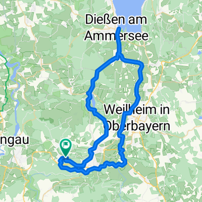
Ammersee-Hohenpeißenberg
A cycling route starting in Hohenpeißenberg, Bavaria, Germany.
Overview
About this route
- -:--
- Duration
- 97.1 km
- Distance
- 597 m
- Ascent
- 597 m
- Descent
- ---
- Avg. speed
- ---
- Max. altitude
Route quality
Waytypes & surfaces along the route
Waytypes
Track
36.9 km
(38 %)
Quiet road
27.2 km
(28 %)
Surfaces
Paved
57.3 km
(59 %)
Unpaved
35 km
(36 %)
Asphalt
55.4 km
(57 %)
Gravel
19.4 km
(20 %)
Continue with Bikemap
Use, edit, or download this cycling route
You would like to ride Ammersee-Hohenpeißenberg or customize it for your own trip? Here is what you can do with this Bikemap route:
Free features
- Save this route as favorite or in collections
- Copy & plan your own version of this route
- Split it into stages to create a multi-day tour
- Sync your route with Garmin or Wahoo
Premium features
Free trial for 3 days, or one-time payment. More about Bikemap Premium.
- Navigate this route on iOS & Android
- Export a GPX / KML file of this route
- Create your custom printout (try it for free)
- Download this route for offline navigation
Discover more Premium features.
Get Bikemap PremiumFrom our community
Other popular routes starting in Hohenpeißenberg
 Hohenpeißenberg - Weilheim
- Distance
- 21 km
- Ascent
- 29 m
- Descent
- 447 m
- Location
- Hohenpeißenberg, Bavaria, Germany
 Coole Tour
- Distance
- 50.3 km
- Ascent
- 513 m
- Descent
- 513 m
- Location
- Hohenpeißenberg, Bavaria, Germany
 Ammersee-Hohenpeißenberg
- Distance
- 97.1 km
- Ascent
- 597 m
- Descent
- 597 m
- Location
- Hohenpeißenberg, Bavaria, Germany
 Coole Tour CLONED FROM ROUTE 988130
- Distance
- 50.3 km
- Ascent
- 513 m
- Descent
- 513 m
- Location
- Hohenpeißenberg, Bavaria, Germany
 Hohenpeißenberg - Forst - Schongau - Hohenpeißenberg
- Distance
- 45.9 km
- Ascent
- 637 m
- Descent
- 636 m
- Location
- Hohenpeißenberg, Bavaria, Germany
 HP - Diessen
- Distance
- 65.2 km
- Ascent
- 319 m
- Descent
- 318 m
- Location
- Hohenpeißenberg, Bavaria, Germany
 Kenzenhütte
- Distance
- 101.3 km
- Ascent
- 710 m
- Descent
- 710 m
- Location
- Hohenpeißenberg, Bavaria, Germany
 Illach
- Distance
- 47.7 km
- Ascent
- 253 m
- Descent
- 252 m
- Location
- Hohenpeißenberg, Bavaria, Germany
Open it in the app