

2010 St Oswald/Furtmühle-Passau
A cycling route starting in Schlägl, Upper Austria, Austria.
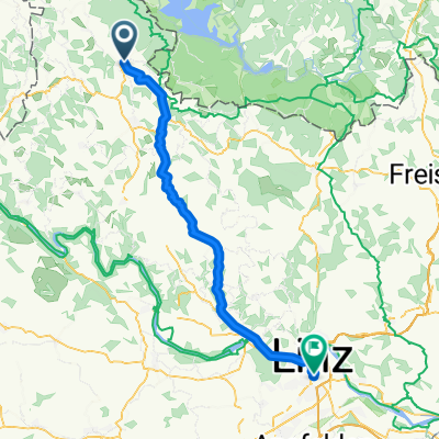
Overview
About this route
regnerischer Tag,bis zur Donau gutes Stück an der Gr Mühl,Stück auf Wanderweg 150 durch den Matsch,dann rüber zur Kl Mühl,
Donauschifffahrt verpasst also erst mal im strömenden Regen weiter per Rad,die Schlögener Schlinge mit klein Fähre gefahren
dann weiter mit Rad bei besser werdendem Wetter bis Passau
letzter Radtag Tour 2010,gesamt etwa 1500KM
- -:--
- Duration
- 80.6 km
- Distance
- 389 m
- Ascent
- 603 m
- Descent
- ---
- Avg. speed
- ---
- Max. altitude
Route highlights
Points of interest along the route
Point of interest after 11.4 km
Hier auf Wanderweg 150...was n Fehler war,schön aber,mit Rad un Gepäck feuchter Murks über STock und Stein
Point of interest after 28.5 km
Schiffahrtsanlegestelle...Schiff um 15 Min verpasst
Point of interest after 33.5 km
mit Minifähre die Schögener Schlinge bis Au gefahren,Radweg auf dieser Seite endet hier
Point of interest after 62.2 km
kein DB mehr in Oberzell...also weiter per Rad
Point of interest after 80.6 km
per Bahn bis Hof...aber Unwetter Bahn bleibt liegen und Übernachtung in regensburg dazwischen geschoben
Continue with Bikemap
Use, edit, or download this cycling route
You would like to ride 2010 St Oswald/Furtmühle-Passau or customize it for your own trip? Here is what you can do with this Bikemap route:
Free features
- Save this route as favorite or in collections
- Copy & plan your own version of this route
- Split it into stages to create a multi-day tour
- Sync your route with Garmin or Wahoo
Premium features
Free trial for 3 days, or one-time payment. More about Bikemap Premium.
- Navigate this route on iOS & Android
- Export a GPX / KML file of this route
- Create your custom printout (try it for free)
- Download this route for offline navigation
Discover more Premium features.
Get Bikemap PremiumFrom our community
Other popular routes starting in Schlägl
 Rohrbach-Berg - Nove Udolí
- Distance
- 57 km
- Ascent
- 737 m
- Descent
- 513 m
- Location
- Schlägl, Upper Austria, Austria
 2010 St Oswald/Furtmühle-Passau
- Distance
- 80.6 km
- Ascent
- 389 m
- Descent
- 603 m
- Location
- Schlägl, Upper Austria, Austria
 2010-Tag25: Runde um die Furthmühle
- Distance
- 7.8 km
- Ascent
- 200 m
- Descent
- 205 m
- Location
- Schlägl, Upper Austria, Austria
 2010-Tag26: Furthmühle-Passau
- Distance
- 80.7 km
- Ascent
- 433 m
- Descent
- 643 m
- Location
- Schlägl, Upper Austria, Austria
 Lipno Stausse Runde oben
- Distance
- 77 km
- Ascent
- 1,247 m
- Descent
- 1,245 m
- Location
- Schlägl, Upper Austria, Austria
 Rohrbach nach Wien 2017
- Distance
- 264.6 km
- Ascent
- 151 m
- Descent
- 555 m
- Location
- Schlägl, Upper Austria, Austria
 Haslach
- Distance
- 47.8 km
- Ascent
- 884 m
- Descent
- 881 m
- Location
- Schlägl, Upper Austria, Austria
 Grüner Weg, Aigen-Schlägl nach Bahnhofplatz, Linz
- Distance
- 59.5 km
- Ascent
- 804 m
- Descent
- 1,110 m
- Location
- Schlägl, Upper Austria, Austria
Open it in the app