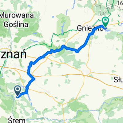
Pogorzelica-przeprawa
A cycling route starting in K贸rnik, Greater Poland Voivodeship, Poland.
Overview
About this route
- -:--
- Duration
- 107.7 km
- Distance
- 154 m
- Ascent
- 154 m
- Descent
- ---
- Avg. speed
- ---
- Max. altitude
Route quality
Waytypes & surfaces along the route
Waytypes
Road
56 km
(52 %)
Quiet road
31.2 km
(29 %)
Surfaces
Paved
84 km
(78 %)
Unpaved
9.7 km
(9 %)
Asphalt
76.5 km
(71 %)
Gravel
5.4 km
(5 %)
Continue with Bikemap
Use, edit, or download this cycling route
You would like to ride Pogorzelica-przeprawa or customize it for your own trip? Here is what you can do with this Bikemap route:
Free features
- Save this route as favorite or in collections
- Copy & plan your own version of this route
- Split it into stages to create a multi-day tour
- Sync your route with Garmin or Wahoo
Premium features
Free trial for 3 days, or one-time payment. More about Bikemap Premium.
- Navigate this route on iOS & Android
- Export a GPX / KML file of this route
- Create your custom printout (try it for free)
- Download this route for offline navigation
Discover more Premium features.
Get Bikemap PremiumFrom our community
Other popular routes starting in K贸rnik
- Almost Springtime
- Distance
- 28.8 km
- Ascent
- 39 m
- Descent
- 36 m
- Location
- K贸rnik, Greater Poland Voivodeship, Poland
- K贸rnik-Zaniemy艣l-艢roda-艢r贸dka-K贸rnik
- Distance
- 55.7 km
- Ascent
- 65 m
- Descent
- 65 m
- Location
- K贸rnik, Greater Poland Voivodeship, Poland
- Niedzielny poranek
- Distance
- 45.1 km
- Ascent
- 68 m
- Descent
- 71 m
- Location
- K贸rnik, Greater Poland Voivodeship, Poland
- K贸rnik - Zaniemy艣l - Czmoniec
- Distance
- 55.2 km
- Ascent
- 97 m
- Descent
- 97 m
- Location
- K贸rnik, Greater Poland Voivodeship, Poland
- K脫RNICKI PIER艢CIE艃 ROWEROWY
- Distance
- 55.1 km
- Ascent
- 97 m
- Descent
- 97 m
- Location
- K贸rnik, Greater Poland Voivodeship, Poland
- Sobotnie otwarcie
- Distance
- 17.8 km
- Ascent
- 32 m
- Descent
- 33 m
- Location
- K贸rnik, Greater Poland Voivodeship, Poland
- Bnin - Herman贸w
- Distance
- 62.1 km
- Ascent
- 101 m
- Descent
- 97 m
- Location
- K贸rnik, Greater Poland Voivodeship, Poland
- Pozna艅ska 77, K贸rnik do Romana Maya 127A, Pozna艅
- Distance
- 20 km
- Ascent
- 129 m
- Descent
- 130 m
- Location
- K贸rnik, Greater Poland Voivodeship, Poland
Open it in the app