

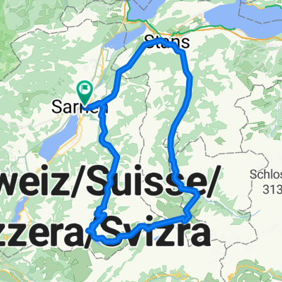
Sarnersee-Giswil-FlüeliRanft
A cycling route starting in Sarnen, Canton of Obwalden, Switzerland.
Overview
About this route
- -:--
- Duration
- 33.5 km
- Distance
- 795 m
- Ascent
- 792 m
- Descent
- ---
- Avg. speed
- ---
- Max. altitude
Route photos


Route quality
Waytypes & surfaces along the route
Waytypes
Quiet road
9 km
(27 %)
Track
6.4 km
(19 %)
Surfaces
Paved
8.4 km
(25 %)
Unpaved
7.6 km
(23 %)
Asphalt
7.1 km
(21 %)
Loose gravel
2.2 km
(7 %)
Continue with Bikemap
Use, edit, or download this cycling route
You would like to ride Sarnersee-Giswil-FlüeliRanft or customize it for your own trip? Here is what you can do with this Bikemap route:
Free features
- Save this route as favorite or in collections
- Copy & plan your own version of this route
- Sync your route with Garmin or Wahoo
Premium features
Free trial for 3 days, or one-time payment. More about Bikemap Premium.
- Navigate this route on iOS & Android
- Export a GPX / KML file of this route
- Create your custom printout (try it for free)
- Download this route for offline navigation
Discover more Premium features.
Get Bikemap PremiumFrom our community
Other popular routes starting in Sarnen
 Tour deluxe
- Distance
- 70.3 km
- Ascent
- 2,111 m
- Descent
- 2,110 m
- Location
- Sarnen, Canton of Obwalden, Switzerland
 Scheidegg
- Distance
- 132.6 km
- Ascent
- 2,362 m
- Descent
- 2,350 m
- Location
- Sarnen, Canton of Obwalden, Switzerland
 Sarnersee-Giswil-FlüeliRanft
- Distance
- 33.5 km
- Ascent
- 795 m
- Descent
- 792 m
- Location
- Sarnen, Canton of Obwalden, Switzerland
 Sportliche Route in Sarnen-Alpnach
- Distance
- 6.3 km
- Ascent
- 245 m
- Descent
- 175 m
- Location
- Sarnen, Canton of Obwalden, Switzerland
 Sarnen-Glaubenbühlen-Galubeberg
- Distance
- 82.9 km
- Ascent
- 2,002 m
- Descent
- 2,002 m
- Location
- Sarnen, Canton of Obwalden, Switzerland
 Mueterschwanderbergtrail
- Distance
- 30.2 km
- Ascent
- 618 m
- Descent
- 617 m
- Location
- Sarnen, Canton of Obwalden, Switzerland
 sobota
- Distance
- 48.5 km
- Ascent
- 1,473 m
- Descent
- 1,473 m
- Location
- Sarnen, Canton of Obwalden, Switzerland
 Over Älggi to Melchsee
- Distance
- 71.6 km
- Ascent
- 2,434 m
- Descent
- 2,406 m
- Location
- Sarnen, Canton of Obwalden, Switzerland
Open it in the app