
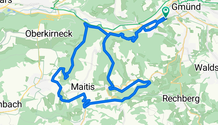
Gmünd - Dehner - Aasrücken - Wäscherschloss - Gmünd
A cycling route starting in Schwäbisch Gmünd, Baden-Wurttemberg, Germany.
Overview
About this route
- -:--
- Duration
- 30.3 km
- Distance
- 480 m
- Ascent
- 480 m
- Descent
- ---
- Avg. speed
- ---
- Max. altitude
Continue with Bikemap
Use, edit, or download this cycling route
You would like to ride Gmünd - Dehner - Aasrücken - Wäscherschloss - Gmünd or customize it for your own trip? Here is what you can do with this Bikemap route:
Free features
- Save this route as favorite or in collections
- Copy & plan your own version of this route
- Sync your route with Garmin or Wahoo
Premium features
Free trial for 3 days, or one-time payment. More about Bikemap Premium.
- Navigate this route on iOS & Android
- Export a GPX / KML file of this route
- Create your custom printout (try it for free)
- Download this route for offline navigation
Discover more Premium features.
Get Bikemap PremiumFrom our community
Other popular routes starting in Schwäbisch Gmünd
 Hohenstaufenrunde
- Distance
- 28.7 km
- Ascent
- 605 m
- Descent
- 605 m
- Location
- Schwäbisch Gmünd, Baden-Wurttemberg, Germany
 Johannisplatz 10, Schwäbisch Gmünd nach Johannisplatz 10, Schwäbisch Gmünd
- Distance
- 55.7 km
- Ascent
- 614 m
- Descent
- 615 m
- Location
- Schwäbisch Gmünd, Baden-Wurttemberg, Germany
 Erste HfG Bike-Tour
- Distance
- 38.4 km
- Ascent
- 882 m
- Descent
- 882 m
- Location
- Schwäbisch Gmünd, Baden-Wurttemberg, Germany
 Rund um Schwäbisch Gmünd
- Distance
- 101.1 km
- Ascent
- 954 m
- Descent
- 949 m
- Location
- Schwäbisch Gmünd, Baden-Wurttemberg, Germany
 Kurze Feierabendrunde
- Distance
- 23.3 km
- Ascent
- 338 m
- Descent
- 351 m
- Location
- Schwäbisch Gmünd, Baden-Wurttemberg, Germany
 alb rauf und runter
- Distance
- 98.6 km
- Ascent
- 1,359 m
- Descent
- 1,361 m
- Location
- Schwäbisch Gmünd, Baden-Wurttemberg, Germany
 Am Steilfall der Alb entlang
- Distance
- 37.7 km
- Ascent
- 289 m
- Descent
- 289 m
- Location
- Schwäbisch Gmünd, Baden-Wurttemberg, Germany
 Kurze Fürtlespass Runde
- Distance
- 34.6 km
- Ascent
- 485 m
- Descent
- 485 m
- Location
- Schwäbisch Gmünd, Baden-Wurttemberg, Germany
Open it in the app