

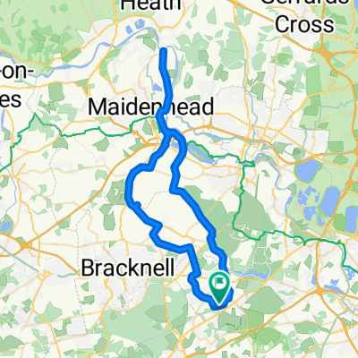
Chobham Road, Ascot to Hasleon, Ongar Hill, Addlestone
A cycling route starting in Sunningdale, England, United Kingdom.
Overview
About this route
- 1 h 37 min
- Duration
- 34.5 km
- Distance
- 512 m
- Ascent
- 533 m
- Descent
- 21.4 km/h
- Avg. speed
- ---
- Max. altitude
Route quality
Waytypes & surfaces along the route
Waytypes
Road
9.3 km
(27 %)
Quiet road
8.3 km
(24 %)
Surfaces
Paved
34.5 km
(100 %)
Asphalt
34.5 km
(100 %)
Continue with Bikemap
Use, edit, or download this cycling route
You would like to ride Chobham Road, Ascot to Hasleon, Ongar Hill, Addlestone or customize it for your own trip? Here is what you can do with this Bikemap route:
Free features
- Save this route as favorite or in collections
- Copy & plan your own version of this route
- Sync your route with Garmin or Wahoo
Premium features
Free trial for 3 days, or one-time payment. More about Bikemap Premium.
- Navigate this route on iOS & Android
- Export a GPX / KML file of this route
- Create your custom printout (try it for free)
- Download this route for offline navigation
Discover more Premium features.
Get Bikemap PremiumFrom our community
Other popular routes starting in Sunningdale
 Viginia Water to Crowthorne
- Distance
- 18 km
- Ascent
- 163 m
- Descent
- 123 m
- Location
- Sunningdale, England, United Kingdom
 Blacknest to Blacknest
- Distance
- 14.9 km
- Ascent
- 147 m
- Descent
- 144 m
- Location
- Sunningdale, England, United Kingdom
 London Road, Ascot to 6 High Street, Woking
- Distance
- 12.5 km
- Ascent
- 50 m
- Descent
- 67 m
- Location
- Sunningdale, England, United Kingdom
 Great Windsor Park
- Distance
- 16.2 km
- Ascent
- 137 m
- Descent
- 137 m
- Location
- Sunningdale, England, United Kingdom
 Sunning Avenue 20, Sunningdale to Sunning Avenue 20, Sunningdale
- Distance
- 51.7 km
- Ascent
- 211 m
- Descent
- 208 m
- Location
- Sunningdale, England, United Kingdom
 Gravel 3 rivers loop
- Distance
- 44.5 km
- Ascent
- 120 m
- Descent
- 119 m
- Location
- Sunningdale, England, United Kingdom
 home to Leith Hill
- Distance
- 47 km
- Ascent
- 628 m
- Descent
- 388 m
- Location
- Sunningdale, England, United Kingdom
 маршрут с Barons Wood, West Drive, Аскот
- Distance
- 87.4 km
- Ascent
- 958 m
- Descent
- 1,032 m
- Location
- Sunningdale, England, United Kingdom
Open it in the app