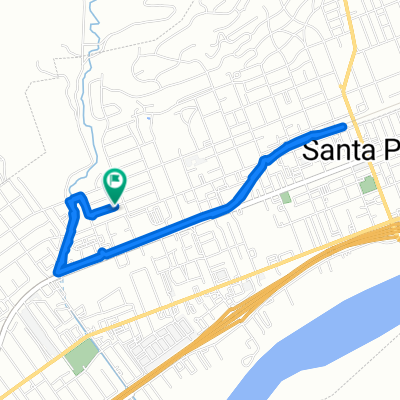
Community-Senior Center, Santa Paula to Acacia Road 450, Santa Paula
- 5.5 km
- 4 m
- 14 m
- Santa Paula, California, United States
A cycling route starting in Santa Paula, California, United States.
Overview
This loop incorporates the two paved roads crossing the mountain ridge between Santa Clara River Valley and the town of Moorpark in Southern California. I went counter-clockwise, taking the longer ascent of Balcom Canyon (southbound) with the longer descent of Grimes Canyon (northbound). The ascents were reasonable except for one brutal (~20%) section, while the descents were consistently gradual.
Grimes Canyon Rd had most cars on it, but it also had a generous shoulder in post places. (I read somewhere that on weekdays that road has many trucks on it hauling gravel from the nearby quarry.) Shoulder was not great on the rest of the route, but then traffic on it was lighter, too.
A lot of this route was part of the Santa Barbara to Santa Clarita stage in 2007 Tour of California. I realized why the Tour route went south all the way to Los Angeles Ave (aka route 118) - pavement on Stockton Road is consistently bad. Next time I would avoid it and take, e.g., Grimes Canyon Rd in its entirety.
created this 15 years ago
Route quality
Road
28.3 km
(54 %)
Quiet road
15.7 km
(30 %)
Undefined
8.4 km
(16 %)
Paved
5.2 km
(10 %)
Asphalt
4.7 km
(9 %)
Concrete
0.5 km
(1 %)
Undefined
47.1 km
(90 %)
Continue with Bikemap
You would like to ride Balcom and Grimes Canyon Loop from Santa Paula or customize it for your own trip? Here is what you can do with this Bikemap route:
Free trial for 3 days, or one-time payment. More about Bikemap Premium.
Discover more Premium features.
Get Bikemap PremiumFrom our community
Open it in the app