

meninting batu layar
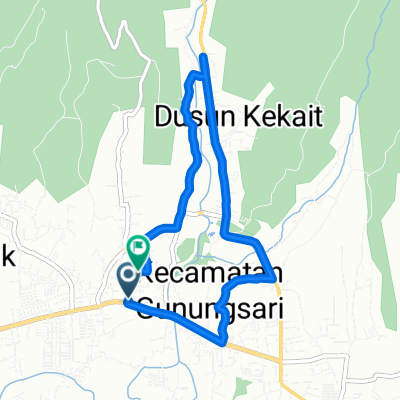
A cycling route starting in Mambalan, West Nusa Tenggara, Indonesia.
Overview
About this route
- 29 min
- Duration
- 7.1 km
- Distance
- 70 m
- Ascent
- 75 m
- Descent
- 14.6 km/h
- Avg. speed
- ---
- Max. altitude

Route photos

Route quality
Waytypes & surfaces along the route
Waytypes
Road
3.5 km
(49 %)
Cycleway
2.2 km
(31 %)
Surfaces
Paved
6.5 km
(91 %)
Unpaved
0.1 km
(2 %)
Asphalt
4.5 km
(64 %)
Paved (undefined)
1.9 km
(27 %)
Continue with Bikemap
Use, edit, or download this cycling route
You would like to ride meninting batu layar or customize it for your own trip? Here is what you can do with this Bikemap route:
Free features
- Save this route as favorite or in collections
- Copy & plan your own version of this route
- Sync your route with Garmin or Wahoo
Premium features
Free trial for 3 days, or one-time payment. More about Bikemap Premium.
- Navigate this route on iOS & Android
- Export a GPX / KML file of this route
- Create your custom printout (try it for free)
- Download this route for offline navigation
Discover more Premium features.
Get Bikemap PremiumFrom our community
Other popular routes starting in Mambalan
 L-6 to L-6
- Distance
- 8.1 km
- Ascent
- 43 m
- Descent
- 84 m
- Location
- Mambalan, West Nusa Tenggara, Indonesia
 Bukit cacing
- Distance
- 42.5 km
- Ascent
- 7 m
- Descent
- 0 m
- Location
- Mambalan, West Nusa Tenggara, Indonesia
 Lombok- Matarm to Gunungsari-Bukit Kedondong-Senggigi
- Distance
- 13.1 km
- Ascent
- 476 m
- Descent
- 497 m
- Location
- Mambalan, West Nusa Tenggara, Indonesia
 15 + 1 peaks plus a monkey forest
- Distance
- 54 km
- Ascent
- 518 m
- Descent
- 518 m
- Location
- Mambalan, West Nusa Tenggara, Indonesia
 Jalan Pariwisata 40, Gunung Sari to Jalan Pariwisata 32, Gunung Sari
- Distance
- 9.9 km
- Ascent
- 87 m
- Descent
- 91 m
- Location
- Mambalan, West Nusa Tenggara, Indonesia
 Jalan Pariwisata 32, Gunung Sari to Jalan Pariwisata 32, Gunung Sari
- Distance
- 15.3 km
- Ascent
- 36 m
- Descent
- 47 m
- Location
- Mambalan, West Nusa Tenggara, Indonesia
 Jalan Pariwisata 14x, Batu Layar to Jalan Kembung 8, Kecamatan Ampenan
- Distance
- 6.5 km
- Ascent
- 82 m
- Descent
- 75 m
- Location
- Mambalan, West Nusa Tenggara, Indonesia
 meninting batu layar
- Distance
- 7.1 km
- Ascent
- 70 m
- Descent
- 75 m
- Location
- Mambalan, West Nusa Tenggara, Indonesia
Open it in the app