
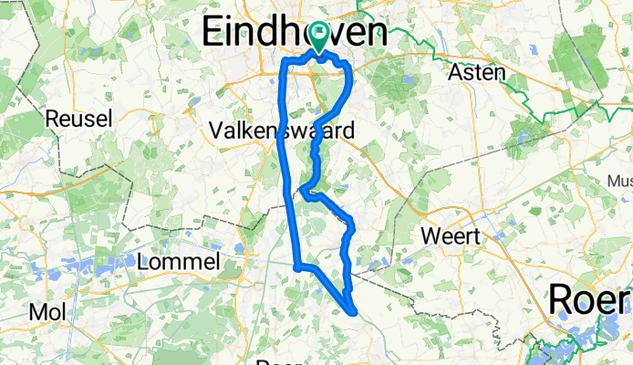
V'waar-Achel-Loozen-Hamont-Kluis
A cycling route starting in De Doornakkers, North Brabant, The Netherlands.
Overview
About this route
- -:--
- Duration
- 71.3 km
- Distance
- 45 m
- Ascent
- 43 m
- Descent
- ---
- Avg. speed
- ---
- Max. altitude
Route quality
Waytypes & surfaces along the route
Waytypes
Cycleway
41.3 km
(58 %)
Quiet road
16.4 km
(23 %)
Surfaces
Paved
44.2 km
(62 %)
Unpaved
1.4 km
(2 %)
Asphalt
34.9 km
(49 %)
Paved (undefined)
6.4 km
(9 %)
Continue with Bikemap
Use, edit, or download this cycling route
You would like to ride V'waar-Achel-Loozen-Hamont-Kluis or customize it for your own trip? Here is what you can do with this Bikemap route:
Free features
- Save this route as favorite or in collections
- Copy & plan your own version of this route
- Sync your route with Garmin or Wahoo
Premium features
Free trial for 3 days, or one-time payment. More about Bikemap Premium.
- Navigate this route on iOS & Android
- Export a GPX / KML file of this route
- Create your custom printout (try it for free)
- Download this route for offline navigation
Discover more Premium features.
Get Bikemap PremiumFrom our community
Other popular routes starting in De Doornakkers
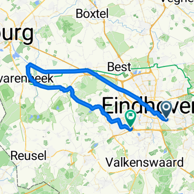
 Kanalenwerk Eindhoven
- Distance
- 73.4 km
- Ascent
- 34 m
- Descent
- 34 m
- Location
- De Doornakkers, North Brabant, The Netherlands
 V'waar-Achel-Loozen-Hamont-Kluis
- Distance
- 71.3 km
- Ascent
- 45 m
- Descent
- 43 m
- Location
- De Doornakkers, North Brabant, The Netherlands
 Rondje Eindhoven-Hamont-Bocholt-Weert-Maarheeze
- Distance
- 80.3 km
- Ascent
- 197 m
- Descent
- 198 m
- Location
- De Doornakkers, North Brabant, The Netherlands
 Eindhoven to lexmond
- Distance
- 84.7 km
- Ascent
- 2,435 m
- Descent
- 2,444 m
- Location
- De Doornakkers, North Brabant, The Netherlands
 Vlasven-Lugeastre Bas 1e advies Bikemap
- Distance
- 937.3 km
- Ascent
- 4,559 m
- Descent
- 3,778 m
- Location
- De Doornakkers, North Brabant, The Netherlands
 Simon van der Stelstraat 36, Eindhoven naar Generaal Cronjéstraat 5, Eindhoven
- Distance
- 11.4 km
- Ascent
- 33 m
- Descent
- 32 m
- Location
- De Doornakkers, North Brabant, The Netherlands
 langs het kanaal naar haghorst en dwars terug
- Distance
- 55 km
- Ascent
- 51 m
- Descent
- 54 m
- Location
- De Doornakkers, North Brabant, The Netherlands
 Cellostraat 10, Eindhoven to De Run 7190, Veldhoven
- Distance
- 11.3 km
- Ascent
- 16 m
- Descent
- 14 m
- Location
- De Doornakkers, North Brabant, The Netherlands
Open it in the app