

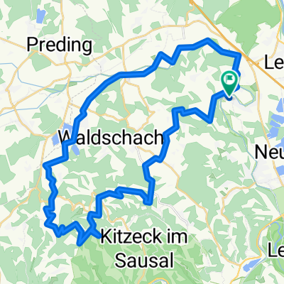
Auf den Spuren von Nestl Opa
A cycling route starting in Lang, Styria, Austria.
Overview
About this route
- -:--
- Duration
- 947.9 km
- Distance
- 6,519 m
- Ascent
- 5,432 m
- Descent
- ---
- Avg. speed
- ---
- Max. altitude

Route quality
Waytypes & surfaces along the route
Waytypes
Quiet road
265.4 km
(28 %)
Track
208.5 km
(22 %)
Surfaces
Paved
673 km
(71 %)
Unpaved
94.8 km
(10 %)
Asphalt
654 km
(69 %)
Gravel
56.9 km
(6 %)
Continue with Bikemap
Use, edit, or download this cycling route
You would like to ride Auf den Spuren von Nestl Opa or customize it for your own trip? Here is what you can do with this Bikemap route:
Free features
- Save this route as favorite or in collections
- Copy & plan your own version of this route
- Split it into stages to create a multi-day tour
- Sync your route with Garmin or Wahoo
Premium features
Free trial for 3 days, or one-time payment. More about Bikemap Premium.
- Navigate this route on iOS & Android
- Export a GPX / KML file of this route
- Create your custom printout (try it for free)
- Download this route for offline navigation
Discover more Premium features.
Get Bikemap PremiumFrom our community
Other popular routes starting in Lang
 Jöß - Kranachberg - Aflenz - Jöss
- Distance
- 47.2 km
- Ascent
- 707 m
- Descent
- 706 m
- Location
- Lang, Styria, Austria
 Radtour 6.9.2025 eBike
- Distance
- 37.7 km
- Ascent
- 945 m
- Descent
- 947 m
- Location
- Lang, Styria, Austria
 eBike Radtour 6.9.2025
- Distance
- 42.2 km
- Ascent
- 1,116 m
- Descent
- 1,118 m
- Location
- Lang, Styria, Austria
 Auf den Spuren von Nestl Opa
- Distance
- 947.9 km
- Ascent
- 6,519 m
- Descent
- 5,432 m
- Location
- Lang, Styria, Austria
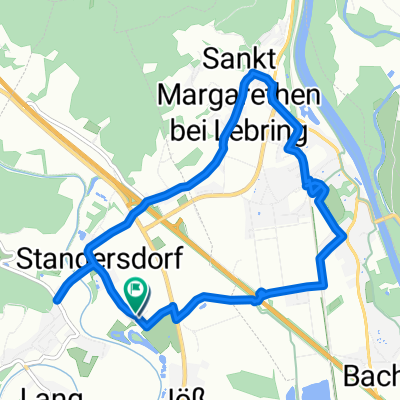 Stangersdorf-Lebring-St.Margarethen-retour
- Distance
- 8.9 km
- Ascent
- 43 m
- Descent
- 46 m
- Location
- Lang, Styria, Austria
 Frannach-Mitterlabill-Schwarzautal-Laubegg
- Distance
- 48.6 km
- Ascent
- 548 m
- Descent
- 547 m
- Location
- Lang, Styria, Austria
 Lebring - Gabersdorf - Wolfsberg - Wildon
- Distance
- 44.4 km
- Ascent
- 230 m
- Descent
- 229 m
- Location
- Lang, Styria, Austria
 Sonntagstour 29.10.2023
- Distance
- 54.2 km
- Ascent
- 1,643 m
- Descent
- 1,642 m
- Location
- Lang, Styria, Austria
Open it in the app