

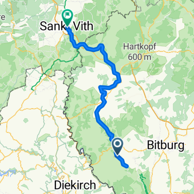
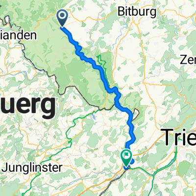
RLP6: Mettendorf - Stadtkyll - Birgel 79km 810hm
A cycling route starting in Mettendorf, Rhineland-Palatinate, Germany.
Overview
About this route
Mettendorf - (Enz Cycle Path) - Arzfeld - Pronsfeld - (Prüm Cycle Path) - Prüm - Stadtkyll - (Kylltal Cycle Path) - Birgel
- -:--
- Duration
- 78.8 km
- Distance
- 486 m
- Ascent
- 331 m
- Descent
- ---
- Avg. speed
- ---
- Max. altitude

Route quality
Waytypes & surfaces along the route
Waytypes
Path
37 km
(47 %)
Track
15 km
(19 %)
Surfaces
Paved
65.4 km
(83 %)
Unpaved
3.2 km
(4 %)
Asphalt
60.7 km
(77 %)
Paved (undefined)
4.7 km
(6 %)
Continue with Bikemap
Use, edit, or download this cycling route
You would like to ride RLP6: Mettendorf - Stadtkyll - Birgel 79km 810hm or customize it for your own trip? Here is what you can do with this Bikemap route:
Free features
- Save this route as favorite or in collections
- Copy & plan your own version of this route
- Sync your route with Garmin or Wahoo
Premium features
Free trial for 3 days, or one-time payment. More about Bikemap Premium.
- Navigate this route on iOS & Android
- Export a GPX / KML file of this route
- Create your custom printout (try it for free)
- Download this route for offline navigation
Discover more Premium features.
Get Bikemap PremiumFrom our community
Other popular routes starting in Mettendorf
 RLP6: Mettendorf - Stadtkyll - Birgel 79km 810hm
- Distance
- 78.8 km
- Ascent
- 486 m
- Descent
- 331 m
- Location
- Mettendorf, Rhineland-Palatinate, Germany
 Böschtour Eifel
- Distance
- 24.5 km
- Ascent
- 421 m
- Descent
- 421 m
- Location
- Mettendorf, Rhineland-Palatinate, Germany
 Mettendorf - Oberbillig
- Distance
- 72.2 km
- Ascent
- 1,062 m
- Descent
- 843 m
- Location
- Mettendorf, Rhineland-Palatinate, Germany
 Mettendorf - Remich
- Distance
- 74 km
- Ascent
- 610 m
- Descent
- 682 m
- Location
- Mettendorf, Rhineland-Palatinate, Germany
 Im Kiemen 12, Mettendorf nach Unnamed Road, Irrhausen
- Distance
- 22.1 km
- Ascent
- 404 m
- Descent
- 306 m
- Location
- Mettendorf, Rhineland-Palatinate, Germany
 Niehler Straße 2, Mettendorf nach Niehler Straße 2, Mettendorf
- Distance
- 52.9 km
- Ascent
- 976 m
- Descent
- 975 m
- Location
- Mettendorf, Rhineland-Palatinate, Germany
 Mettendorf ->Bitburg (21 km)
- Distance
- 20.7 km
- Ascent
- 344 m
- Descent
- 292 m
- Location
- Mettendorf, Rhineland-Palatinate, Germany
 Mettendorf - Oberbillig
- Distance
- 42.1 km
- Ascent
- 808 m
- Descent
- 924 m
- Location
- Mettendorf, Rhineland-Palatinate, Germany
Open it in the app