

Po otwocku
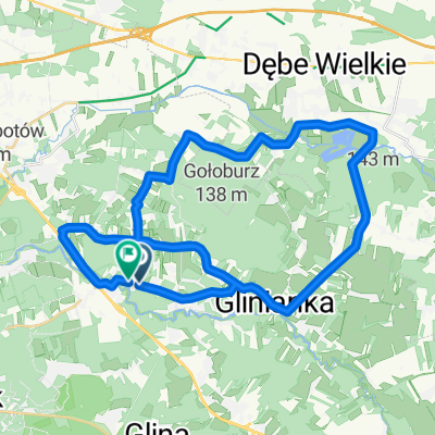
A cycling route starting in Otwock, Masovian Voivodeship, Poland.
Overview
About this route
- -:--
- Duration
- 17.1 km
- Distance
- 40 m
- Ascent
- 39 m
- Descent
- ---
- Avg. speed
- ---
- Max. altitude
Route quality
Waytypes & surfaces along the route
Waytypes
Quiet road
6.7 km
(39 %)
Road
3.8 km
(22 %)
Surfaces
Paved
9.9 km
(58 %)
Unpaved
1.7 km
(10 %)
Asphalt
9.9 km
(58 %)
Ground
1 km
(6 %)
Route highlights
Points of interest along the route
Point of interest after 0 km
Dworzec Kolejowy
Point of interest after 0.8 km
Sanatorium Przygody
Point of interest after 1.4 km
Sanatorium Krukowskiego
Point of interest after 2 km
Willa Racówka
Point of interest after 2.2 km
Willa na Górce
Point of interest after 2.4 km
Willa Odo Bujwida
Point of interest after 2.4 km
Świdermajer
Point of interest after 2.5 km
Świdermajer
Point of interest after 2.5 km
Świdermajer
Point of interest after 2.5 km
willa Szeliga
Point of interest after 2.5 km
Hotel Polski
Point of interest after 2.6 km
Willa Podole
Point of interest after 2.7 km
Willa gen. Jacymirskiego (I)
Point of interest after 2.8 km
Kościół św. Wincentego a'Paulo
Point of interest after 2.9 km
Sanatorium M. Chmielewskiej, F. Wiśniewskiego, S. Krzyżanowskiego
Point of interest after 3.1 km
Sanatorium doktora Józefa Geislera
Point of interest after 3.1 km
Dom doktora W. Wajdenfelda
Point of interest after 3.1 km
Willa gen. Jacymirskiego (II)
Point of interest after 3.6 km
Reymontówka
Point of interest after 4.1 km
Sanatorium Sejmikowe im. Stanisława Okulicza
Point of interest after 6.5 km
Sanatorium Wojskowe
Point of interest after 8.7 km
Zofiówka
Point of interest after 9.4 km
Sanatorium Towarzystwa Brijus
Point of interest after 9.9 km
Sanatorium m.st. Warszawy
Point of interest after 11.9 km
Kasperczówka
Point of interest after 12.1 km
Sierociniec
Point of interest after 12.3 km
Dom Julii Klauzińskiej (jedna z pierwszych polskich lekarek)
Point of interest after 12.4 km
Pensjonat Eden
Point of interest after 12.5 km
Willa Kahana (I)
Point of interest after 12.5 km
Willa Kahana (II)
Point of interest after 13.3 km
Apteka o sklep kolonialny
Point of interest after 13.4 km
Wojskowy Szpital Lotniczy
Point of interest after 13.7 km
Willa Róża
Point of interest after 14 km
Posiadłość rodziny Badiorów
Point of interest after 14.1 km
Drukarnia świętych ksiąg żydowskich
Point of interest after 14.4 km
Willa Lucyna-Oleńka
Point of interest after 14.5 km
Kino Promyk
Point of interest after 14.5 km
Kamienica barona Lessera
Point of interest after 14.6 km
Willa Julia
Point of interest after 15.1 km
Teatr im. S. Jaracza
Point of interest after 15.2 km
Urząd Miasta, Willa Sierakowskiego
Point of interest after 15.5 km
Uzdrowisko Abrama Górewicza
Point of interest after 16.1 km
Dom Uzdrowiskowy
Continue with Bikemap
Use, edit, or download this cycling route
You would like to ride Po otwocku or customize it for your own trip? Here is what you can do with this Bikemap route:
Free features
- Save this route as favorite or in collections
- Copy & plan your own version of this route
- Sync your route with Garmin or Wahoo
Premium features
Free trial for 3 days, or one-time payment. More about Bikemap Premium.
- Navigate this route on iOS & Android
- Export a GPX / KML file of this route
- Create your custom printout (try it for free)
- Download this route for offline navigation
Discover more Premium features.
Get Bikemap PremiumFrom our community
Other popular routes starting in Otwock
 otwock
- Distance
- 18.6 km
- Ascent
- 61 m
- Descent
- 68 m
- Location
- Otwock, Masovian Voivodeship, Poland
 Wspaniała, Otwock do Wspaniała, Otwock
- Distance
- 37.6 km
- Ascent
- 130 m
- Descent
- 128 m
- Location
- Otwock, Masovian Voivodeship, Poland
 Świder Wisła
- Distance
- 35.5 km
- Ascent
- 46 m
- Descent
- 29 m
- Location
- Otwock, Masovian Voivodeship, Poland
 małe koło
- Distance
- 49.2 km
- Ascent
- 88 m
- Descent
- 86 m
- Location
- Otwock, Masovian Voivodeship, Poland
 Po otwocku
- Distance
- 17.1 km
- Ascent
- 40 m
- Descent
- 39 m
- Location
- Otwock, Masovian Voivodeship, Poland
 Mieszanka
- Distance
- 11.4 km
- Ascent
- 27 m
- Descent
- 28 m
- Location
- Otwock, Masovian Voivodeship, Poland
 Maraton Terenowy Blisko Otwocka 14.IV.2012
- Distance
- 75.5 km
- Ascent
- 138 m
- Descent
- 138 m
- Location
- Otwock, Masovian Voivodeship, Poland
 Chełm 2015 dzień 1
- Distance
- 127.8 km
- Ascent
- 220 m
- Descent
- 171 m
- Location
- Otwock, Masovian Voivodeship, Poland
Open it in the app