
Arbeit
- 12.3 km
- 54 m
- 130 m
- Pentling, Bavaria, Germany
A cycling route starting in Pentling, Bavaria, Germany.
Overview
Marked cycling route
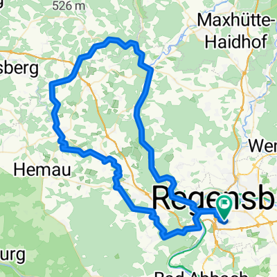
Length: 39 kmDifficulty: medium, two longer climbsSurface: partly gravel paths, roadsStart/Finish: Pentling
General route description:Pentling – Graß – Oberisling – Oberhinkhofen – Köfering – Alteglofsheim – Thalmassing – Weillohe – Niedergebraching – Pentling
Sights:
Oberhinkofen: local heritage museum
Egglfing: romanesque church with early Gothic frescoes
Köfering: castle with St. Martin's church
Alteglofsheim: rococo castle with Asam hall
Neueglofsheim: castle, 1000-year-old Wolfgang oak
Weillohe: hall church
Thalmassing: pilgrimage church of St. Bäumel
Additional information:The starting point is Pentling. From the urban area of Regensburg, you can usually reach the route fastest via Unterislinger Weg and then join the loop in Oberisling.The actual route: Crossing the bridge of the A 93 motorway and about 500 m later crossing the B 16 leads the way to Graß. It continues gently downhill through Leoprechting to Oberisling. Just after Oberisling you carefully cross Unterislinger Weg. About 500 meters further, the path turns south and leads via Unterisling to the forest edge at Höfling castle and from there continues along a gravel path to Oberhinkofen, then on a cycle path along the county road to Piesenkofen. At the edge of the training area, the path leads to Einthal. Please pay attention to the signs there regarding the military exclusion zone! Continuing through Egglfing and Köfering to Alteglofsheim, turn right at the church towards Thalmassing, after about 200 m stay left towards Neueglofsheim, on paved land consolidation road and unpaved forest road (good path condition) to Neueglofsheim. From Thalmassing there is then a climb up to the height of St. Bäumel (about 40 meters elevation gain) and from there via Weillohe, Untermassing to Seedorf (caution when crossing the state road before Seedorf!). About 600 m after Seedorf, the path continues in a north-west direction through Niedergebraching and over Großberg back to the starting point Pentling.
created this 15 years ago
Route highlights
Wolfgangseiche
Continue with Bikemap
You would like to ride Radweg R9 Landkreis Regensburg or customize it for your own trip? Here is what you can do with this Bikemap route:
Free trial for 3 days, or one-time payment. More about Bikemap Premium.
Discover more Premium features.
Get Bikemap PremiumFrom our community
Open it in the app