
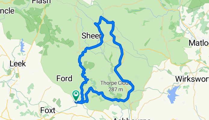
Route 4 Waterhouses circuit to Manifold and Tissington Trails
A cycling route starting in Mayfield, England, United Kingdom.
Overview
About this route
Waterhouses, Hulme End, Hartington, Tissington, Thorpe, Ilam and return.
- -:--
- Duration
- 54.8 km
- Distance
- 497 m
- Ascent
- 503 m
- Descent
- ---
- Avg. speed
- 339 m
- Max. altitude

Route quality
Waytypes & surfaces along the route
Waytypes
Cycleway
29.1 km
(53 %)
Quiet road
20.8 km
(38 %)
Surfaces
Paved
15.9 km
(29 %)
Unpaved
17 km
(31 %)
Gravel
17 km
(31 %)
Asphalt
15.9 km
(29 %)
Undefined
21.9 km
(40 %)
Continue with Bikemap
Use, edit, or download this cycling route
You would like to ride Route 4 Waterhouses circuit to Manifold and Tissington Trails or customize it for your own trip? Here is what you can do with this Bikemap route:
Free features
- Save this route as favorite or in collections
- Copy & plan your own version of this route
- Sync your route with Garmin or Wahoo
Premium features
Free trial for 3 days, or one-time payment. More about Bikemap Premium.
- Navigate this route on iOS & Android
- Export a GPX / KML file of this route
- Create your custom printout (try it for free)
- Download this route for offline navigation
Discover more Premium features.
Get Bikemap PremiumFrom our community
Other popular routes starting in Mayfield
 course
- Distance
- 2.3 km
- Ascent
- 0 m
- Descent
- 0 m
- Location
- Mayfield, England, United Kingdom
 Manifold valley South to North 13km
- Distance
- 13.4 km
- Ascent
- 124 m
- Descent
- 126 m
- Location
- Mayfield, England, United Kingdom
 brookleys lake
- Distance
- 6.3 km
- Ascent
- 148 m
- Descent
- 148 m
- Location
- Mayfield, England, United Kingdom
 Pt4 The Peak District
- Distance
- 71.5 km
- Ascent
- 777 m
- Descent
- 770 m
- Location
- Mayfield, England, United Kingdom
 Field House Farm, Common Lane, Stoke-on-Trent to Field House Farm, Common Lane, Stoke-on-Trent
- Distance
- 23.7 km
- Ascent
- 473 m
- Descent
- 472 m
- Location
- Mayfield, England, United Kingdom
 2 day Manifold - Ashbourne Peak Tour
- Distance
- 90.8 km
- Ascent
- 649 m
- Descent
- 727 m
- Location
- Mayfield, England, United Kingdom
 Alton 15
- Distance
- 25 km
- Ascent
- 394 m
- Descent
- 392 m
- Location
- Mayfield, England, United Kingdom
 Denstone - Oakamoor
- Distance
- 6.8 km
- Ascent
- 56 m
- Descent
- 41 m
- Location
- Mayfield, England, United Kingdom
Open it in the app