

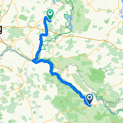
Dannenberg - Ventschauer Fischteiche - Dannenberg - 10.11.2019
A cycling route starting in Dannenberg, Lower Saxony, Germany.
Overview
About this route
The Ventschau fish ponds offer wonderful photo opportunities. Especially during the autumn season, it is very beautiful here.
- -:--
- Duration
- 62.2 km
- Distance
- 598 m
- Ascent
- 601 m
- Descent
- ---
- Avg. speed
- ---
- Max. altitude

Route photos


Route quality
Waytypes & surfaces along the route
Waytypes
Path
18.7 km
(30 %)
Quiet road
14.9 km
(24 %)
Surfaces
Paved
42.3 km
(68 %)
Unpaved
12.4 km
(20 %)
Asphalt
41.1 km
(66 %)
Ground
6.8 km
(11 %)
Continue with Bikemap
Use, edit, or download this cycling route
You would like to ride Dannenberg - Ventschauer Fischteiche - Dannenberg - 10.11.2019 or customize it for your own trip? Here is what you can do with this Bikemap route:
Free features
- Save this route as favorite or in collections
- Copy & plan your own version of this route
- Sync your route with Garmin or Wahoo
Premium features
Free trial for 3 days, or one-time payment. More about Bikemap Premium.
- Navigate this route on iOS & Android
- Export a GPX / KML file of this route
- Create your custom printout (try it for free)
- Download this route for offline navigation
Discover more Premium features.
Get Bikemap PremiumFrom our community
Other popular routes starting in Dannenberg
 Amphiebientour
- Distance
- 29 km
- Ascent
- 26 m
- Descent
- 26 m
- Location
- Dannenberg, Lower Saxony, Germany
 Von Dannenberg nach Wendisch Evern
- Distance
- 71.1 km
- Ascent
- 269 m
- Descent
- 239 m
- Location
- Dannenberg, Lower Saxony, Germany
 Dannenberg - Ventschauer Fischteiche - Dannenberg - 10.11.2019
- Distance
- 62.2 km
- Ascent
- 598 m
- Descent
- 601 m
- Location
- Dannenberg, Lower Saxony, Germany
 Hitzacker 09.08.2018
- Distance
- 20.5 km
- Ascent
- 26 m
- Descent
- 26 m
- Location
- Dannenberg, Lower Saxony, Germany
 Dannenberg O Arendsee
- Distance
- 114.5 km
- Ascent
- 178 m
- Descent
- 177 m
- Location
- Dannenberg, Lower Saxony, Germany
 Morgenrunde 20.03.2019
- Distance
- 8.6 km
- Ascent
- 10 m
- Descent
- 10 m
- Location
- Dannenberg, Lower Saxony, Germany
 ELDannenbergEschede
- Distance
- 79.8 km
- Ascent
- 249 m
- Descent
- 194 m
- Location
- Dannenberg, Lower Saxony, Germany
 Dannenberg - Mölln
- Distance
- 102.7 km
- Ascent
- 349 m
- Descent
- 337 m
- Location
- Dannenberg, Lower Saxony, Germany
Open it in the app