
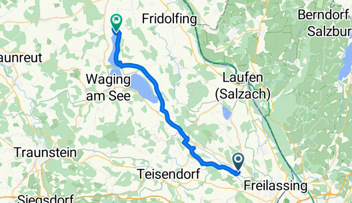
Buchholzweg 9B, Saaldorf-Surheim nach Am See, Traunstein, gemeindefreies Gebiet
A cycling route starting in Ainring, Bavaria, Germany.
Overview
About this route
- 3 h 34 min
- Duration
- 27.6 km
- Distance
- 228 m
- Ascent
- 212 m
- Descent
- 7.8 km/h
- Avg. speed
- ---
- Avg. speed

Route quality
Waytypes & surfaces along the route
Waytypes
Quiet road
12.2 km
(44 %)
Path
4.7 km
(17 %)
Surfaces
Paved
16.1 km
(58 %)
Unpaved
2.8 km
(10 %)
Asphalt
16 km
(58 %)
Gravel
1.7 km
(6 %)
Continue with Bikemap
Use, edit, or download this cycling route
You would like to ride Buchholzweg 9B, Saaldorf-Surheim nach Am See, Traunstein, gemeindefreies Gebiet or customize it for your own trip? Here is what you can do with this Bikemap route:
Free features
- Save this route as favorite or in collections
- Copy & plan your own version of this route
- Sync your route with Garmin or Wahoo
Premium features
Free trial for 3 days, or one-time payment. More about Bikemap Premium.
- Navigate this route on iOS & Android
- Export a GPX / KML file of this route
- Create your custom printout (try it for free)
- Download this route for offline navigation
Discover more Premium features.
Get Bikemap PremiumFrom our community
Other popular routes starting in Ainring
 2011 Ainring - Golling Österreich
- Distance
- 45.1 km
- Ascent
- 221 m
- Descent
- 174 m
- Location
- Ainring, Bavaria, Germany
 Gerade Fahrt in Saaldorf-Surheim
- Distance
- 32.2 km
- Ascent
- 0 m
- Descent
- 0 m
- Location
- Ainring, Bavaria, Germany
 Sa TS Wochinger und Schönram
- Distance
- 64.5 km
- Ascent
- 887 m
- Descent
- 894 m
- Location
- Ainring, Bavaria, Germany
 högl-runde
- Distance
- 26.1 km
- Ascent
- 200 m
- Descent
- 200 m
- Location
- Ainring, Bavaria, Germany
 Freilassing-Taching
- Distance
- 64.6 km
- Ascent
- 290 m
- Descent
- 287 m
- Location
- Ainring, Bavaria, Germany
 Einfache 50 km Tour fast ohne Höhenmeter
- Distance
- 61.8 km
- Ascent
- 151 m
- Descent
- 151 m
- Location
- Ainring, Bavaria, Germany
 Route im Schneckentempo in Anger
- Distance
- 20.5 km
- Ascent
- 1,040 m
- Descent
- 210 m
- Location
- Ainring, Bavaria, Germany
 Mitterfelden- wagingersee strandbad und zuürck
- Distance
- 41.3 km
- Ascent
- 132 m
- Descent
- 132 m
- Location
- Ainring, Bavaria, Germany
Open it in the app