

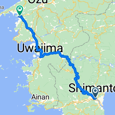
Shimanto to 浦戸大橋, Kochi
A cycling route starting in Nakamura, Kochi, Japan.
Overview
About this route
- 13 h 7 min
- Duration
- 136.7 km
- Distance
- 1,150 m
- Ascent
- 1,155 m
- Descent
- 10.4 km/h
- Avg. speed
- ---
- Max. altitude

Continue with Bikemap
Use, edit, or download this cycling route
You would like to ride Shimanto to 浦戸大橋, Kochi or customize it for your own trip? Here is what you can do with this Bikemap route:
Free features
- Save this route as favorite or in collections
- Copy & plan your own version of this route
- Split it into stages to create a multi-day tour
- Sync your route with Garmin or Wahoo
Premium features
Free trial for 3 days, or one-time payment. More about Bikemap Premium.
- Navigate this route on iOS & Android
- Export a GPX / KML file of this route
- Create your custom printout (try it for free)
- Download this route for offline navigation
Discover more Premium features.
Get Bikemap PremiumFrom our community
Other popular routes starting in Nakamura
 Shimanto to Ashizuri
- Distance
- 52.9 km
- Ascent
- 949 m
- Descent
- 935 m
- Location
- Nakamura, Kochi, Japan
 2004/04/30中村-八幡浜
- Distance
- 108.5 km
- Ascent
- 985 m
- Descent
- 986 m
- Location
- Nakamura, Kochi, Japan
 黑潮町Kuroshio-宿毛Sukumo P-D5
- Distance
- 90 km
- Ascent
- 837 m
- Descent
- 845 m
- Location
- Nakamura, Kochi, Japan
 足摺チャレンジングコース
- Distance
- 152.6 km
- Ascent
- 4,776 m
- Descent
- 4,775 m
- Location
- Nakamura, Kochi, Japan
 Day 560
- Distance
- 65 km
- Ascent
- 732 m
- Descent
- 732 m
- Location
- Nakamura, Kochi, Japan
 Shimanto City Tosa Taisho (MUTEMUKA)
- Distance
- 71.1 km
- Ascent
- 1,100 m
- Descent
- 973 m
- Location
- Nakamura, Kochi, Japan
 Shimanto River Ride 1 way
- Distance
- 34.7 km
- Ascent
- 502 m
- Descent
- 481 m
- Location
- Nakamura, Kochi, Japan
 Shimanto to 浦戸大橋, Kochi
- Distance
- 136.7 km
- Ascent
- 1,150 m
- Descent
- 1,155 m
- Location
- Nakamura, Kochi, Japan
Open it in the app