

2008/09_Von Häger zum Beutling
A cycling route starting in Werther, North Rhine-Westphalia, Germany.
Overview
About this route
WICHTIGER HINWEIS:
Das Verwenden der Tour erfolgt auf eigene Gefahr. Der Autor der Tour schließt jegliche Haftung für durch Verwendung des Angebots entstandene Schäden aus. Die Beschreibung und Bewertung der Tour stellt nur eine subjektive Einschätzung des Autors dar.
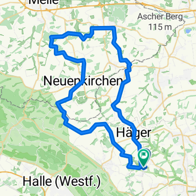
Eine sehr schöne, sehr abwechslungsreiche Sonntagstour durch Feld, Wald und Wiesen.
Als Sehenswürdigkeit lohnt sich der Aussichtsturm beim Beutling. Eine Einkehrmöglichkeit besteht dort auch gleich: "Zum Beutling".
Die Wanderwege! auf den sogenannten Nebenstrecken sind nach meiner Erfahrung technisch deutlich abwechslungsreicher als z.B. die Waldwege auf dem Hauptkamm des Teutos, und dazu an Sonntagen trotzdem kaum begangen und befahren.
Dauer: ca. 4,5 h Netto bei gemütlichem Tempo und inkl. Pause.
Zuerst ab Werther dem X folgen
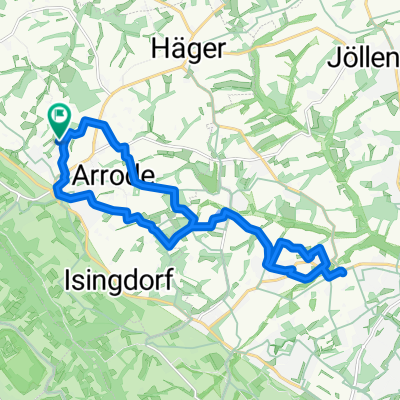
Auf der Rücktour ab Beutling dem M folgen (teilweise Markierungen schwer zu finden)
Ab Haus Brinke: dem Eichblatt-Weg folgen.
- -:--
- Duration
- 38.3 km
- Distance
- 434 m
- Ascent
- 434 m
- Descent
- ---
- Avg. speed
- ---
- Max. altitude

Route highlights
Points of interest along the route

Photo after 20.6 km
Continue with Bikemap
Use, edit, or download this cycling route
You would like to ride 2008/09_Von Häger zum Beutling or customize it for your own trip? Here is what you can do with this Bikemap route:
Free features
- Save this route as favorite or in collections
- Copy & plan your own version of this route
- Sync your route with Garmin or Wahoo
Premium features
Free trial for 3 days, or one-time payment. More about Bikemap Premium.
- Navigate this route on iOS & Android
- Export a GPX / KML file of this route
- Create your custom printout (try it for free)
- Download this route for offline navigation
Discover more Premium features.
Get Bikemap PremiumFrom our community
Other popular routes starting in Werther
 Beautifil Road from Halle to Bielefeld
- Distance
- 10.8 km
- Ascent
- 297 m
- Descent
- 330 m
- Location
- Werther, North Rhine-Westphalia, Germany
 Ascheloh-bRothenfelde-uz 42km
- Distance
- 42 km
- Ascent
- 239 m
- Descent
- 230 m
- Location
- Werther, North Rhine-Westphalia, Germany
 Frühlingsrunde am 31.3.2009
- Distance
- 44.5 km
- Ascent
- 255 m
- Descent
- 245 m
- Location
- Werther, North Rhine-Westphalia, Germany
 2008/09_Von Häger zum Beutling
- Distance
- 38.3 km
- Ascent
- 434 m
- Descent
- 434 m
- Location
- Werther, North Rhine-Westphalia, Germany
 Route im Schneckentempo in Werther (Westfalen)
- Distance
- 18.5 km
- Ascent
- 213 m
- Descent
- 216 m
- Location
- Werther, North Rhine-Westphalia, Germany
 Dornberg-Neuenkirchen und zurück
- Distance
- 34.7 km
- Ascent
- 239 m
- Descent
- 241 m
- Location
- Werther, North Rhine-Westphalia, Germany
 Von Werther zum Griechen Lindos
- Distance
- 19.2 km
- Ascent
- 100 m
- Descent
- 101 m
- Location
- Werther, North Rhine-Westphalia, Germany
 Tour zu den drei "Zwillingswindrädern" im Ravensberger Hügelland mit Fotos
- Distance
- 46 km
- Ascent
- 348 m
- Descent
- 329 m
- Location
- Werther, North Rhine-Westphalia, Germany
Open it in the app