
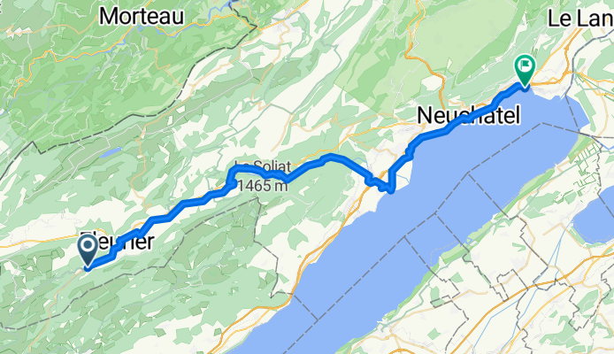
Buttes-Neuchatel
A cycling route starting in Fleurier, Canton of Neuchâtel, Switzerland.
Overview
About this route
- 2 h 58 min
- Duration
- 48 km
- Distance
- 190 m
- Ascent
- 529 m
- Descent
- 16.2 km/h
- Avg. speed
- ---
- Max. altitude

Route quality
Waytypes & surfaces along the route
Waytypes
Quiet road
24.5 km
(51 %)
Track
9.1 km
(19 %)
Surfaces
Paved
25.9 km
(54 %)
Unpaved
1.9 km
(4 %)
Asphalt
19.2 km
(40 %)
Paved (undefined)
6.7 km
(14 %)
Continue with Bikemap
Use, edit, or download this cycling route
You would like to ride Buttes-Neuchatel or customize it for your own trip? Here is what you can do with this Bikemap route:
Free features
- Save this route as favorite or in collections
- Copy & plan your own version of this route
- Sync your route with Garmin or Wahoo
Premium features
Free trial for 3 days, or one-time payment. More about Bikemap Premium.
- Navigate this route on iOS & Android
- Export a GPX / KML file of this route
- Create your custom printout (try it for free)
- Download this route for offline navigation
Discover more Premium features.
Get Bikemap PremiumFrom our community
Other popular routes starting in Fleurier
 Fleurier-diverse Cols-Yverdon
- Distance
- 53.9 km
- Ascent
- 1,027 m
- Descent
- 1,336 m
- Location
- Fleurier, Canton of Neuchâtel, Switzerland
 Val-de-Travers - Grand Canyon
- Distance
- 47.3 km
- Ascent
- 267 m
- Descent
- 581 m
- Location
- Fleurier, Canton of Neuchâtel, Switzerland
 buttes - boudry
- Distance
- 29.1 km
- Ascent
- 195 m
- Descent
- 517 m
- Location
- Fleurier, Canton of Neuchâtel, Switzerland
 Fleurier - Lac des Taillères - Brévine 56-3-761
- Distance
- 39.4 km
- Ascent
- 683 m
- Descent
- 684 m
- Location
- Fleurier, Canton of Neuchâtel, Switzerland
 22.4.2018
- Distance
- 72.2 km
- Ascent
- 168 m
- Descent
- 476 m
- Location
- Fleurier, Canton of Neuchâtel, Switzerland
 Jura 5
- Distance
- 35.5 km
- Ascent
- 675 m
- Descent
- 669 m
- Location
- Fleurier, Canton of Neuchâtel, Switzerland
 Fleurier - Chaux du Milieu - Brévine
- Distance
- 50.1 km
- Ascent
- 693 m
- Descent
- 696 m
- Location
- Fleurier, Canton of Neuchâtel, Switzerland
 e1 Fleurier - Poligny
- Distance
- 95.9 km
- Ascent
- 450 m
- Descent
- 902 m
- Location
- Fleurier, Canton of Neuchâtel, Switzerland
Open it in the app