Štíty - H. Heřmanice - Chudoba - Herbortice - Tatenice - Hoštejn - Drozdovská pila - Štíty
A cycling route starting in Štíty, Olomoucký kraj, Czechia.
Overview
About this route
Between Herborticemi and Tatenicemi, there are 5 panel bridges, and the route between Hoštejn and Štíty leads through the beautiful valley of the Březná River.
- -:--
- Duration
- 38.3 km
- Distance
- 468 m
- Ascent
- 468 m
- Descent
- ---
- Avg. speed
- ---
- Max. altitude
Route highlights
Points of interest along the route
Point of interest after 29.6 km
Drozdovská pila
Continue with Bikemap
Use, edit, or download this cycling route
You would like to ride Štíty - H. Heřmanice - Chudoba - Herbortice - Tatenice - Hoštejn - Drozdovská pila - Štíty or customize it for your own trip? Here is what you can do with this Bikemap route:
Free features
- Save this route as favorite or in collections
- Copy & plan your own version of this route
- Sync your route with Garmin or Wahoo
Premium features
Free trial for 3 days, or one-time payment. More about Bikemap Premium.
- Navigate this route on iOS & Android
- Export a GPX / KML file of this route
- Create your custom printout (try it for free)
- Download this route for offline navigation
Discover more Premium features.
Get Bikemap PremiumFrom our community
Other popular routes starting in Štíty
- Rampušák 2014 130 km
- Distance
- 127.2 km
- Ascent
- 1,529 m
- Descent
- 1,529 m
- Location
- Štíty, Olomoucký kraj, Czechia
- Rampušák 2011 - dlouhá CLONED FROM ROUTE 797007
- Distance
- 191.1 km
- Ascent
- 2,141 m
- Descent
- 2,143 m
- Location
- Štíty, Olomoucký kraj, Czechia
- Rampušák 2016 - 120 km
- Distance
- 119.6 km
- Ascent
- 1,292 m
- Descent
- 1,285 m
- Location
- Štíty, Olomoucký kraj, Czechia
- Kelly's Rampušák 2012 - Silnice krátká
- Distance
- 139.5 km
- Ascent
- 1,609 m
- Descent
- 1,609 m
- Location
- Štíty, Olomoucký kraj, Czechia
- Kelly's Rampušák 2012 - silnice dlouhá
- Distance
- 179.2 km
- Ascent
- 2,102 m
- Descent
- 2,101 m
- Location
- Štíty, Olomoucký kraj, Czechia
- Rampušák 2014 - 180 km
- Distance
- 175.1 km
- Ascent
- 2,071 m
- Descent
- 2,071 m
- Location
- Štíty, Olomoucký kraj, Czechia
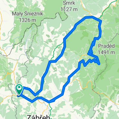
- Štíty - Březná - Písařov - Sv. Trojice - Severomoravská chata - Křížová hora - Č. Voda - Heroltice - Štíty
- Distance
- 38.7 km
- Ascent
- 511 m
- Descent
- 511 m
- Location
- Štíty, Olomoucký kraj, Czechia
- Štíty - Heroltice - Č. Voda - M. Karlov - Severomoravská chata - Hedeč - Králíky - Boříkovice - Č. Voda - Březná - Štíty
- Distance
- 50.4 km
- Ascent
- 508 m
- Descent
- 507 m
- Location
- Štíty, Olomoucký kraj, Czechia
Open it in the app