

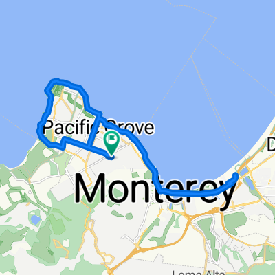
USA CA 11 Monterey-Big Sur
A cycling route starting in Pacific Grove, California, United States.
Overview
About this route
Ursprüngliche Tagestour wurde geändert. Ca. 20 km führt sie entlang der wunderbaren Küste von Carmel by the Sea. Wir sind begeistert von dieser wildromantischen Küstenlinie. Lt. Garmin 63 km, 726 hm
- -:--
- Duration
- 57.6 km
- Distance
- 481 m
- Ascent
- 408 m
- Descent
- ---
- Avg. speed
- ---
- Max. altitude

Continue with Bikemap
Use, edit, or download this cycling route
You would like to ride USA CA 11 Monterey-Big Sur or customize it for your own trip? Here is what you can do with this Bikemap route:
Free features
- Save this route as favorite or in collections
- Copy & plan your own version of this route
- Sync your route with Garmin or Wahoo
Premium features
Free trial for 3 days, or one-time payment. More about Bikemap Premium.
- Navigate this route on iOS & Android
- Export a GPX / KML file of this route
- Create your custom printout (try it for free)
- Download this route for offline navigation
Discover more Premium features.
Get Bikemap PremiumFrom our community
Other popular routes starting in Pacific Grove
 PG & Monterey ride
- Distance
- 24.5 km
- Ascent
- 130 m
- Descent
- 130 m
- Location
- Pacific Grove, California, United States
 737 Marino Pines Rd, Pacific Grove to 743 Marino Pines Rd, Pacific Grove
- Distance
- 34.6 km
- Ascent
- 380 m
- Descent
- 383 m
- Location
- Pacific Grove, California, United States
 1814–1832 Sunset Dr, Pacific Grove to 3224 17 Mile Dr, Pebble Beach
- Distance
- 11.1 km
- Ascent
- 51 m
- Descent
- 59 m
- Location
- Pacific Grove, California, United States
 Pacific Grove Loop
- Distance
- 14.5 km
- Ascent
- 82 m
- Descent
- 86 m
- Location
- Pacific Grove, California, United States
 today
today- Distance
- 11.2 km
- Ascent
- 119 m
- Descent
- 119 m
- Location
- Pacific Grove, California, United States
 Easy ride in Pacific Grove
- Distance
- 3 km
- Ascent
- 35 m
- Descent
- 40 m
- Location
- Pacific Grove, California, United States
 17 mile drive
- Distance
- 33.5 km
- Ascent
- 118 m
- Descent
- 144 m
- Location
- Pacific Grove, California, United States
 Lighthouse Avenue 1249, Pacific Grove to Lighthouse Avenue 1249, Pacific Grove
- Distance
- 8.4 km
- Ascent
- 41 m
- Descent
- 45 m
- Location
- Pacific Grove, California, United States
Open it in the app