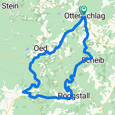
Ottenschlag_Traunstein 1
A cycling route starting in Ottenschlag, Lower Austria, Austria.
Overview
About this route
Cycling route of about 30 km. The bike route leads on paved farm roads and side streets through untouched Waldviertel landscape.
- -:--
- Duration
- 38.4 km
- Distance
- 625 m
- Ascent
- 623 m
- Descent
- ---
- Avg. speed
- ---
- Max. altitude
Route quality
Waytypes & surfaces along the route
Waytypes
Road
11.1 km
(29 %)
Quiet road
9.6 km
(25 %)
Surfaces
Paved
13.1 km
(34 %)
Unpaved
5.8 km
(15 %)
Asphalt
12.3 km
(32 %)
Gravel
2.7 km
(7 %)
Continue with Bikemap
Use, edit, or download this cycling route
You would like to ride Ottenschlag_Traunstein 1 or customize it for your own trip? Here is what you can do with this Bikemap route:
Free features
- Save this route as favorite or in collections
- Copy & plan your own version of this route
- Sync your route with Garmin or Wahoo
Premium features
Free trial for 3 days, or one-time payment. More about Bikemap Premium.
- Navigate this route on iOS & Android
- Export a GPX / KML file of this route
- Create your custom printout (try it for free)
- Download this route for offline navigation
Discover more Premium features.
Get Bikemap PremiumFrom our community
Other popular routes starting in Ottenschlag
Ottenschlag leicht- Distance
- 28.3 km
- Ascent
- 310 m
- Descent
- 318 m
- Location
- Ottenschlag, Lower Austria, Austria
Ottenschlag - Seiberer- Distance
- 44.7 km
- Ascent
- 968 m
- Descent
- 973 m
- Location
- Ottenschlag, Lower Austria, Austria
B36 Ottenschlag-Zwettl- Distance
- 23.6 km
- Ascent
- 172 m
- Descent
- 512 m
- Location
- Ottenschlag, Lower Austria, Austria
Ottenschlag_Traunstein 1- Distance
- 38.4 km
- Ascent
- 625 m
- Descent
- 623 m
- Location
- Ottenschlag, Lower Austria, Austria
Jauerling von Ottenschlag- Distance
- 58.4 km
- Ascent
- 1,617 m
- Descent
- 1,633 m
- Location
- Ottenschlag, Lower Austria, Austria
Ottenschlag - Purk -Ottenschlag- Distance
- 30 km
- Ascent
- 414 m
- Descent
- 412 m
- Location
- Ottenschlag, Lower Austria, Austria
Schönbach - Gerungs - Jagenbach - Zwettl- Distance
- 104.3 km
- Ascent
- 909 m
- Descent
- 909 m
- Location
- Ottenschlag, Lower Austria, Austria
Kombitour 17 & 19- Distance
- 46.3 km
- Ascent
- 953 m
- Descent
- 950 m
- Location
- Ottenschlag, Lower Austria, Austria
Open it in the app


