

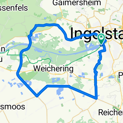
Mooshäuseltour 9/2010 Roth
A cycling route starting in Ingolstadt, Bavaria, Germany.
Overview
About this route
Nice little beginner's tour
-
Along the Gerolfinger Str river course
-
to the Forsterweiher
-
towards Gerolfing
-
to the Schafierrsee
-
along the Danube to the Neuburg weir
-
Grünau Castle
-
cycling route is signposted
-
tip: beer garden in Weichering - you pass right by it
-
to the Danube power station in Ingolstadt
-
Ingolstadt gravel lake
-
into the moor to Mooshäusel
- -:--
- Duration
- 35.4 km
- Distance
- 41 m
- Ascent
- 44 m
- Descent
- ---
- Avg. speed
- ---
- Max. altitude

Continue with Bikemap
Use, edit, or download this cycling route
You would like to ride Mooshäuseltour 9/2010 Roth or customize it for your own trip? Here is what you can do with this Bikemap route:
Free features
- Save this route as favorite or in collections
- Copy & plan your own version of this route
- Sync your route with Garmin or Wahoo
Premium features
Free trial for 3 days, or one-time payment. More about Bikemap Premium.
- Navigate this route on iOS & Android
- Export a GPX / KML file of this route
- Create your custom printout (try it for free)
- Download this route for offline navigation
Discover more Premium features.
Get Bikemap PremiumFrom our community
Other popular routes starting in Ingolstadt
 17.07.04 Ingolst.-Sandersdorf
- Distance
- 32.7 km
- Ascent
- 108 m
- Descent
- 76 m
- Location
- Ingolstadt, Bavaria, Germany
 E7. 11.7.25 Ingolstadt nach Karpfenberg
- Distance
- 71.9 km
- Ascent
- 329 m
- Descent
- 401 m
- Location
- Ingolstadt, Bavaria, Germany
 Mooshäuseltour 9/2010 Roth
- Distance
- 35.4 km
- Ascent
- 41 m
- Descent
- 44 m
- Location
- Ingolstadt, Bavaria, Germany
 Donaumoos GUS 46
- Distance
- 45.9 km
- Ascent
- 62 m
- Descent
- 65 m
- Location
- Ingolstadt, Bavaria, Germany
 8 Berge rund um Kipfenberg
- Distance
- 98.7 km
- Ascent
- 1,206 m
- Descent
- 1,208 m
- Location
- Ingolstadt, Bavaria, Germany
 Denkendorf - Oberreichenbach
- Distance
- 136.3 km
- Ascent
- 977 m
- Descent
- 1,077 m
- Location
- Ingolstadt, Bavaria, Germany
 Ingolstadt-Hofstetten
- Distance
- 63.1 km
- Ascent
- 379 m
- Descent
- 378 m
- Location
- Ingolstadt, Bavaria, Germany
 Radltour IN - RID - KEH - ABG - VOH - IN
- Distance
- 109 km
- Ascent
- 165 m
- Descent
- 169 m
- Location
- Ingolstadt, Bavaria, Germany
Open it in the app