

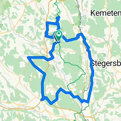
JFA Maiazell Alpl Niederalpl
A cycling route starting in Sebersdorf, Styria, Austria.
Overview
About this route
- -:--
- Duration
- 126.2 km
- Distance
- 2,657 m
- Ascent
- 2,173 m
- Descent
- ---
- Avg. speed
- 1,243 m
- Max. altitude
Route quality
Waytypes & surfaces along the route
Waytypes
Road
3.8 km
(3 %)
Quiet road
2.5 km
(2 %)
Surfaces
Paved
97.2 km
(77 %)
Asphalt
95.9 km
(76 %)
Paved (undefined)
1.3 km
(1 %)
Undefined
29 km
(23 %)
Route highlights
Points of interest along the route
Point of interest after 61.5 km
Point of interest after 126.1 km
Continue with Bikemap
Use, edit, or download this cycling route
You would like to ride JFA Maiazell Alpl Niederalpl or customize it for your own trip? Here is what you can do with this Bikemap route:
Free features
- Save this route as favorite or in collections
- Copy & plan your own version of this route
- Split it into stages to create a multi-day tour
- Sync your route with Garmin or Wahoo
Premium features
Free trial for 3 days, or one-time payment. More about Bikemap Premium.
- Navigate this route on iOS & Android
- Export a GPX / KML file of this route
- Create your custom printout (try it for free)
- Download this route for offline navigation
Discover more Premium features.
Get Bikemap PremiumFrom our community
Other popular routes starting in Sebersdorf
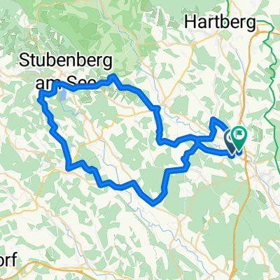
 2.túra 1.nap
- Distance
- 74.5 km
- Ascent
- 831 m
- Descent
- 818 m
- Location
- Sebersdorf, Styria, Austria
 JFA Hartberg Ring
- Distance
- 41.9 km
- Ascent
- 763 m
- Descent
- 716 m
- Location
- Sebersdorf, Styria, Austria
 JFA Maiazell Fischbach Stanz Turnau
- Distance
- 120.3 km
- Ascent
- 2,755 m
- Descent
- 2,248 m
- Location
- Sebersdorf, Styria, Austria
 neustift-hartl-hofkirchen-kulm-pischelsdorf-kleinsteinbach-aufenberg-ebersdorf
- Distance
- 58.6 km
- Ascent
- 879 m
- Descent
- 881 m
- Location
- Sebersdorf, Styria, Austria
 JFA Maiazell Alpl Niederalpl
- Distance
- 126.2 km
- Ascent
- 2,657 m
- Descent
- 2,173 m
- Location
- Sebersdorf, Styria, Austria
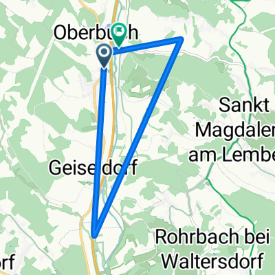 Unterbuch 2 nach Oberbuch 9
- Distance
- 8.6 km
- Ascent
- 8 m
- Descent
- 3 m
- Location
- Sebersdorf, Styria, Austria
 JFA - Training Reigersdburg
- Distance
- 92.8 km
- Ascent
- 623 m
- Descent
- 623 m
- Location
- Sebersdorf, Styria, Austria
 JFA Training vom 24. Mai 2010
- Distance
- 68.6 km
- Ascent
- 524 m
- Descent
- 533 m
- Location
- Sebersdorf, Styria, Austria
Open it in the app