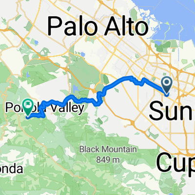
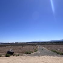
Stevens Creek Trail, Mountain View to 745 S Bernardo Ave, Sunnyvale
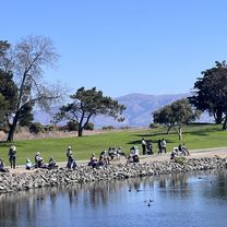
A cycling route starting in Mountain View, California, United States.
Overview
About this route
- 57 min
- Duration
- 9.1 km
- Distance
- 6 m
- Ascent
- 8 m
- Descent
- 9.5 km/h
- Avg. speed
- ---
- Max. altitude
Route quality
Waytypes & surfaces along the route
Waytypes
Cycleway
8.7 km
(96 %)
Pedestrian area
0.2 km
(2 %)
Surfaces
Paved
8.8 km
(97 %)
Asphalt
6.3 km
(70 %)
Paved (undefined)
1.2 km
(14 %)
Continue with Bikemap
Use, edit, or download this cycling route
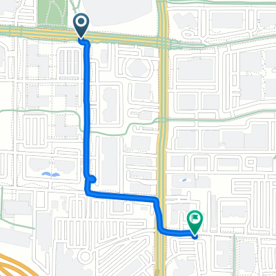
You would like to ride Stevens Creek Trail, Mountain View to 745 S Bernardo Ave, Sunnyvale or customize it for your own trip? Here is what you can do with this Bikemap route:
Free features
- Save this route as favorite or in collections
- Copy & plan your own version of this route
- Sync your route with Garmin or Wahoo
Premium features
Free trial for 3 days, or one-time payment. More about Bikemap Premium.
- Navigate this route on iOS & Android
- Export a GPX / KML file of this route
- Create your custom printout (try it for free)
- Download this route for offline navigation
Discover more Premium features.
Get Bikemap PremiumFrom our community
Other popular routes starting in Mountain View
- Moody quick
- Distance
- 19.1 km
- Ascent
- 233 m
- Descent
- 234 m
- Location
- Mountain View, California, United States
- Route in Mountain View
- Distance
- 14.7 km
- Ascent
- 171 m
- Descent
- 172 m
- Location
- Mountain View, California, United States
- Charleston & Mayfield Slough from Shoreline
- Distance
- 15.4 km
- Ascent
- 40 m
- Descent
- 37 m
- Location
- Mountain View, California, United States
- 601–695 Leong Dr, Mountain View to 685 Leong Dr, Mountain View
- Distance
- 14.8 km
- Ascent
- 0 m
- Descent
- 6 m
- Location
- Mountain View, California, United States
- Los altos hills
- Distance
- 25.2 km
- Ascent
- 254 m
- Descent
- 254 m
- Location
- Mountain View, California, United States
- RG-9-PM Loop
- Distance
- 54.4 km
- Ascent
- 891 m
- Descent
- 891 m
- Location
- Mountain View, California, United States
- Tied House - Los Altos Hill Loop (Long)
- Distance
- 45.1 km
- Ascent
- 420 m
- Descent
- 418 m
- Location
- Mountain View, California, United States
- 487 Thompson Ave, Mountain View to 2378 Jane Ln, Mountain View
- Distance
- 22 km
- Ascent
- 0 m
- Descent
- 6 m
- Location
- Mountain View, California, United States
Open it in the app