

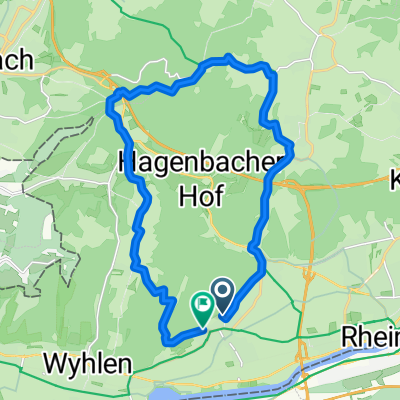
Herten - Lörrach hoch
A cycling route starting in Grenzach-Wyhlen, Baden-Wurttemberg, Germany.
Overview
About this route
- -:--
- Duration
- 28.8 km
- Distance
- 477 m
- Ascent
- 476 m
- Descent
- ---
- Avg. speed
- ---
- Max. altitude
Route quality
Waytypes & surfaces along the route
Waytypes
Track
22.8 km
(79 %)
Quiet road
2.3 km
(8 %)
Surfaces
Paved
8.4 km
(29 %)
Unpaved
20.2 km
(70 %)
Gravel
12.1 km
(42 %)
Asphalt
5.5 km
(19 %)
Continue with Bikemap
Use, edit, or download this cycling route
You would like to ride Herten - Lörrach hoch or customize it for your own trip? Here is what you can do with this Bikemap route:
Free features
- Save this route as favorite or in collections
- Copy & plan your own version of this route
- Sync your route with Garmin or Wahoo
Premium features
Free trial for 3 days, or one-time payment. More about Bikemap Premium.
- Navigate this route on iOS & Android
- Export a GPX / KML file of this route
- Create your custom printout (try it for free)
- Download this route for offline navigation
Discover more Premium features.
Get Bikemap PremiumFrom our community
Other popular routes starting in Grenzach-Wyhlen
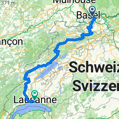 von Wyhlen nach Lausanne
- Distance
- 289.8 km
- Ascent
- 6,193 m
- Descent
- 6,003 m
- Location
- Grenzach-Wyhlen, Baden-Wurttemberg, Germany
 2 duessel dorf rein basel
- Distance
- 757.4 km
- Ascent
- 123 m
- Descent
- 331 m
- Location
- Grenzach-Wyhlen, Baden-Wurttemberg, Germany
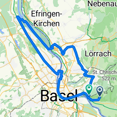 Grenzach-Petite Camargue
- Distance
- 43.1 km
- Ascent
- 166 m
- Descent
- 242 m
- Location
- Grenzach-Wyhlen, Baden-Wurttemberg, Germany
 Herten - Ottwangen - Ruhrberg - Herten
- Distance
- 20.3 km
- Ascent
- 480 m
- Descent
- 477 m
- Location
- Grenzach-Wyhlen, Baden-Wurttemberg, Germany
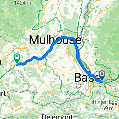 Mülhausen - Montbéliard
- Distance
- 74.7 km
- Ascent
- 211 m
- Descent
- 137 m
- Location
- Grenzach-Wyhlen, Baden-Wurttemberg, Germany
 Chrischona Rundfahrt
- Distance
- 34.7 km
- Ascent
- 439 m
- Descent
- 439 m
- Location
- Grenzach-Wyhlen, Baden-Wurttemberg, Germany
 Badischer Weinradweg - Etappe 1: Markgräflerland
- Distance
- 77.2 km
- Ascent
- 915 m
- Descent
- 942 m
- Location
- Grenzach-Wyhlen, Baden-Wurttemberg, Germany
 Herten - Lörrach hoch
- Distance
- 28.8 km
- Ascent
- 477 m
- Descent
- 476 m
- Location
- Grenzach-Wyhlen, Baden-Wurttemberg, Germany
Open it in the app