

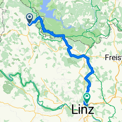
Mühlviertel bis Linz
A cycling route starting in Aigen im Mühlkreis, Upper Austria, Austria.
Overview
About this route
Take the Mühlkreisbahn to Aigen/Schlägl. Tour with many climbs and, from Hellmonsödt, very nice long descents that reward you for your efforts. Day trip.
- -:--
- Duration
- 74.2 km
- Distance
- 1,188 m
- Ascent
- 1,161 m
- Descent
- ---
- Avg. speed
- 878 m
- Max. altitude
Route quality
Waytypes & surfaces along the route
Waytypes
Road
40.8 km
(55 %)
Quiet road
19.3 km
(26 %)
Surfaces
Paved
47.5 km
(64 %)
Unpaved
8.2 km
(11 %)
Asphalt
47.5 km
(64 %)
Gravel
6.7 km
(9 %)
Continue with Bikemap
Use, edit, or download this cycling route
You would like to ride Mühlviertel bis Linz or customize it for your own trip? Here is what you can do with this Bikemap route:
Free features
- Save this route as favorite or in collections
- Copy & plan your own version of this route
- Sync your route with Garmin or Wahoo
Premium features
Free trial for 3 days, or one-time payment. More about Bikemap Premium.
- Navigate this route on iOS & Android
- Export a GPX / KML file of this route
- Create your custom printout (try it for free)
- Download this route for offline navigation
Discover more Premium features.
Get Bikemap PremiumFrom our community
Other popular routes starting in Aigen im Mühlkreis
 802 Sonnenwald
- Distance
- 24.2 km
- Ascent
- 330 m
- Descent
- 331 m
- Location
- Aigen im Mühlkreis, Upper Austria, Austria
 Aigen - St. Thomas - Lipno
- Distance
- 60.6 km
- Ascent
- 676 m
- Descent
- 676 m
- Location
- Aigen im Mühlkreis, Upper Austria, Austria
 Mühlviertel bis Linz
- Distance
- 74.2 km
- Ascent
- 1,188 m
- Descent
- 1,161 m
- Location
- Aigen im Mühlkreis, Upper Austria, Austria
 Krakau Heimweg 6
- Distance
- 185.3 km
- Ascent
- 6,498 m
- Descent
- 6,691 m
- Location
- Aigen im Mühlkreis, Upper Austria, Austria
 Aigen Schlägel - Lipno - Linz
- Distance
- 144.3 km
- Ascent
- 781 m
- Descent
- 1,078 m
- Location
- Aigen im Mühlkreis, Upper Austria, Austria
 Moldaustauseerunde
- Distance
- 41.5 km
- Ascent
- 693 m
- Descent
- 695 m
- Location
- Aigen im Mühlkreis, Upper Austria, Austria
 Mühltalradweg
- Distance
- 28.9 km
- Ascent
- 241 m
- Descent
- 518 m
- Location
- Aigen im Mühlkreis, Upper Austria, Austria
 Böhmerwald -Tour
- Distance
- 69.5 km
- Ascent
- 532 m
- Descent
- 531 m
- Location
- Aigen im Mühlkreis, Upper Austria, Austria
Open it in the app