

0
- 36.9 km
- 494 m
- 721 m
- Sighișoara, Mureș County, Romania
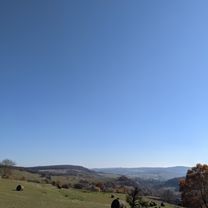
A cycling route starting in Sighișoara, Mureș County, Romania.
Overview
The first 3,5 km are on a public road usually with less traffic. The next 3,5 are a mild climb on a country road and pasture. Once on the top of the hill and in the forest follow the bike trail towards South marked with blue cross. After approx 6 km follow Via Transilvanica trail on country roads back to Sighisoara.
created this 5 years ago
Continue with Bikemap
You would like to ride Cycling around Sighisoara or customize it for your own trip? Here is what you can do with this Bikemap route:
Free trial for 3 days, or one-time payment. More about Bikemap Premium.
Discover more Premium features.
Get Bikemap PremiumFrom our community
Open it in the app


