

Michigan Tour
Michigan Bike Tour - Part 2
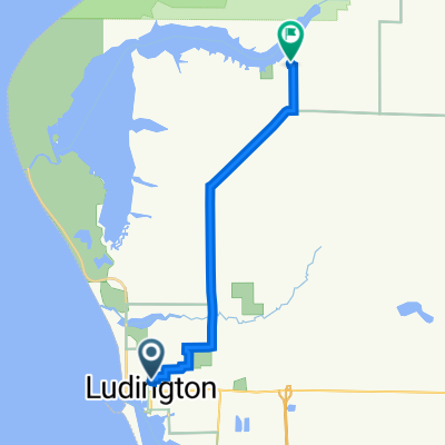
A cycling route starting in Ludington, Michigan, United States.
Overview
About this route
Start: Ludington State Park, Ludington, MI
End: Sleeping Bear Dunes - Platte River Campground, Sleeping Bear Dunes National Lakeshore, Lake Twp, MI
Distance: 76.9mi
Camp/Stay: Sleeping Bear Dunes Campground
- -:--
- Duration
- 123.9 km
- Distance
- 469 m
- Ascent
- 459 m
- Descent
- ---
- Avg. speed
- ---
- Max. altitude

Part of
Michigan Tour
2 stages
Route quality
Waytypes & surfaces along the route
Waytypes
Road
37.2 km
(30 %)
Quiet road
6.2 km
(5 %)
Surfaces
Paved
119 km
(96 %)
Unpaved
1.2 km
(1 %)
Paved (undefined)
74.4 km
(60 %)
Asphalt
44.6 km
(36 %)
Continue with Bikemap
Use, edit, or download this cycling route
You would like to ride Michigan Bike Tour - Part 2 or customize it for your own trip? Here is what you can do with this Bikemap route:
Free features
- Save this route as favorite or in collections
- Copy & plan your own version of this route
- Split it into stages to create a multi-day tour
- Sync your route with Garmin or Wahoo
Premium features
Free trial for 3 days, or one-time payment. More about Bikemap Premium.
- Navigate this route on iOS & Android
- Export a GPX / KML file of this route
- Create your custom printout (try it for free)
- Download this route for offline navigation
Discover more Premium features.
Get Bikemap PremiumFrom our community
Other popular routes starting in Ludington
 123 W Ludington Ave, Ludington to 208 N Robert St, Ludington
- Distance
- 0.9 km
- Ascent
- 0 m
- Descent
- 3 m
- Location
- Ludington, Michigan, United States
 Michigan Bike Tour - Part 2
- Distance
- 123.9 km
- Ascent
- 469 m
- Descent
- 459 m
- Location
- Ludington, Michigan, United States
 Ludington SP to Orchard Beach SP
- Distance
- 50 km
- Ascent
- 101 m
- Descent
- 86 m
- Location
- Ludington, Michigan, United States
 Upper Lake Michigan
- Distance
- 1,143.5 km
- Ascent
- 5,447 m
- Descent
- 5,442 m
- Location
- Ludington, Michigan, United States
 Luddington to Restaurant
- Distance
- 17.9 km
- Ascent
- 41 m
- Descent
- 54 m
- Location
- Ludington, Michigan, United States
 318 N James St, Ludington to 6181 N Peterson Rd, Ludington
- Distance
- 15.9 km
- Ascent
- 49 m
- Descent
- 39 m
- Location
- Ludington, Michigan, United States
 208 N Robert St, Ludington to 318 N James St, Ludington
- Distance
- 0.7 km
- Ascent
- 3 m
- Descent
- 0 m
- Location
- Ludington, Michigan, United States
 400 S Harrison St, Ludington to 200–234 Bridge St, Elk Rapids
- Distance
- 177.3 km
- Ascent
- 903 m
- Descent
- 904 m
- Location
- Ludington, Michigan, United States
Open it in the app