

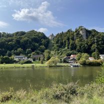
Danube River part 3 (Kelheim to Passau) - Germany
KW2 Weltenburg abbey by ferry to Kelheim (Germany)
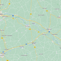
A cycling route starting in Essing, Bavaria, Germany.
Overview
About this route
- -:--
- Duration
- 4.6 km
- Distance
- 0 m
- Ascent
- 0 m
- Descent
- ---
- Avg. speed
- 0 m
- Max. altitude

Part of
Route quality
Waytypes & surfaces along the route
Waytypes
Cycleway
4.5 km
(97 %)
Pedestrian area
0.1 km
(3 %)
Surfaces
Paved
0.1 km
(3 %)
Asphalt
0.1 km
(3 %)
Undefined
4.5 km
(97 %)
Continue with Bikemap
Use, edit, or download this cycling route
You would like to ride KW2 Weltenburg abbey by ferry to Kelheim (Germany) or customize it for your own trip? Here is what you can do with this Bikemap route:
Free features
- Save this route as favorite or in collections
- Copy & plan your own version of this route
- Sync your route with Garmin or Wahoo
Premium features
Free trial for 3 days, or one-time payment. More about Bikemap Premium.
- Navigate this route on iOS & Android
- Export a GPX / KML file of this route
- Create your custom printout (try it for free)
- Download this route for offline navigation
Discover more Premium features.
Get Bikemap PremiumFrom our community
Other popular routes starting in Essing
 Kehlheim-Regensburg 31.8.2021
- Distance
- 45.6 km
- Ascent
- 182 m
- Descent
- 194 m
- Location
- Essing, Bavaria, Germany
 Von Altessing nach Regensburg
- Distance
- 43.1 km
- Ascent
- 176 m
- Descent
- 185 m
- Location
- Essing, Bavaria, Germany
 2013 Weltenburg-Regensburg-Bahntrasse Falkenstein-Walderbach
- Distance
- 84.6 km
- Ascent
- 351 m
- Descent
- 341 m
- Location
- Essing, Bavaria, Germany
 48.926, 11.802 a 49.106, 11.444
- Distance
- 55.5 km
- Ascent
- 285 m
- Descent
- 252 m
- Location
- Essing, Bavaria, Germany
 2017 Weltenburg Kloster-Nandlstadt/Baumgarten
- Distance
- 52.3 km
- Ascent
- 276 m
- Descent
- 143 m
- Location
- Essing, Bavaria, Germany
 Essing Altmühltal RF
- Distance
- 31.1 km
- Ascent
- 180 m
- Descent
- 183 m
- Location
- Essing, Bavaria, Germany
 D_Bayern_Essing-Schulerloch-Obernederhweg-Schlaufe-26)_RR-23km-530hm
- Distance
- 23 km
- Ascent
- 649 m
- Descent
- 649 m
- Location
- Essing, Bavaria, Germany
 Vom Schulerloch nach Dietfurt
- Distance
- 29.3 km
- Ascent
- 76 m
- Descent
- 64 m
- Location
- Essing, Bavaria, Germany
Open it in the app