

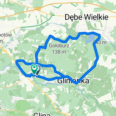
Świdry Wielkie - Emów
A cycling route starting in Otwock, Masovian Voivodeship, Poland.
Overview
About this route
Wzdłuż rzeki Świder.
- -:--
- Duration
- 27.4 km
- Distance
- 55 m
- Ascent
- 55 m
- Descent
- ---
- Avg. speed
- ---
- Max. altitude

Route photos


Route quality
Waytypes & surfaces along the route
Waytypes
Path
19.4 km
(71 %)
Track
2.8 km
(10 %)
Surfaces
Paved
3 km
(11 %)
Unpaved
8 km
(29 %)
Ground
6.5 km
(24 %)
Asphalt
2.8 km
(10 %)
Continue with Bikemap
Use, edit, or download this cycling route
You would like to ride Świdry Wielkie - Emów or customize it for your own trip? Here is what you can do with this Bikemap route:
Free features
- Save this route as favorite or in collections
- Copy & plan your own version of this route
- Sync your route with Garmin or Wahoo
Premium features
Free trial for 3 days, or one-time payment. More about Bikemap Premium.
- Navigate this route on iOS & Android
- Export a GPX / KML file of this route
- Create your custom printout (try it for free)
- Download this route for offline navigation
Discover more Premium features.
Get Bikemap PremiumFrom our community
Other popular routes starting in Otwock
 małe koło
- Distance
- 49.2 km
- Ascent
- 88 m
- Descent
- 86 m
- Location
- Otwock, Masovian Voivodeship, Poland
 otwock
- Distance
- 18.6 km
- Ascent
- 61 m
- Descent
- 68 m
- Location
- Otwock, Masovian Voivodeship, Poland
 Józefa Piłsudskiego 25a, Otwock do Józefa Piłsudskiego 25, Otwock
- Distance
- 18.6 km
- Ascent
- 151 m
- Descent
- 192 m
- Location
- Otwock, Masovian Voivodeship, Poland
 Świdry Wielkie - Emów
- Distance
- 27.4 km
- Ascent
- 55 m
- Descent
- 55 m
- Location
- Otwock, Masovian Voivodeship, Poland
 Chełm 2015 dzień 1
- Distance
- 127.8 km
- Ascent
- 220 m
- Descent
- 171 m
- Location
- Otwock, Masovian Voivodeship, Poland
 Świder Wisła
- Distance
- 35.5 km
- Ascent
- 46 m
- Descent
- 29 m
- Location
- Otwock, Masovian Voivodeship, Poland
 Wspaniała, Otwock do Wspaniała, Otwock
- Distance
- 37.6 km
- Ascent
- 130 m
- Descent
- 128 m
- Location
- Otwock, Masovian Voivodeship, Poland
 Wisła i Świder
- Distance
- 10.3 km
- Ascent
- 25 m
- Descent
- 25 m
- Location
- Otwock, Masovian Voivodeship, Poland
Open it in the app