

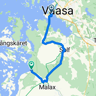
Institutgatan 51, Vasa to Institutgatan 51, Vasa
A cycling route starting in Vaasa, Ostrobothnia, Finland.
Overview
About this route
- 41 min
- Duration
- 14.3 km
- Distance
- 57 m
- Ascent
- 57 m
- Descent
- 21.1 km/h
- Avg. speed
- ---
- Max. altitude

Route quality
Waytypes & surfaces along the route
Waytypes
Cycleway
12.5 km
(87 %)
Quiet road
1 km
(7 %)
Surfaces
Paved
11.5 km
(80 %)
Unpaved
1.1 km
(8 %)
Asphalt
11.2 km
(78 %)
Unpaved (undefined)
1.1 km
(8 %)
Continue with Bikemap
Use, edit, or download this cycling route
You would like to ride Institutgatan 51, Vasa to Institutgatan 51, Vasa or customize it for your own trip? Here is what you can do with this Bikemap route:
Free features
- Save this route as favorite or in collections
- Copy & plan your own version of this route
- Sync your route with Garmin or Wahoo
Premium features
Free trial for 3 days, or one-time payment. More about Bikemap Premium.
- Navigate this route on iOS & Android
- Export a GPX / KML file of this route
- Create your custom printout (try it for free)
- Download this route for offline navigation
Discover more Premium features.
Get Bikemap PremiumFrom our community
Other popular routes starting in Vaasa
 Institutgatan 51, Vasa to Institutgatan 51, Vasa
- Distance
- 14.3 km
- Ascent
- 57 m
- Descent
- 57 m
- Location
- Vaasa, Ostrobothnia, Finland
 Infjärden runt
- Distance
- 14.6 km
- Ascent
- 63 m
- Descent
- 62 m
- Location
- Vaasa, Ostrobothnia, Finland
 200+200 lördag 16.6.18
- Distance
- 202.4 km
- Ascent
- 0 m
- Descent
- 0 m
- Location
- Vaasa, Ostrobothnia, Finland
 Day 9: Vaasa - Fädobu (105km)
- Distance
- 104.6 km
- Ascent
- 80 m
- Descent
- 86 m
- Location
- Vaasa, Ostrobothnia, Finland
 Svezia 2014 c) => Giro del Baltico 2)
- Distance
- 476.8 km
- Ascent
- 178 m
- Descent
- 168 m
- Location
- Vaasa, Ostrobothnia, Finland
 Vaasa Cycling
- Distance
- 31.6 km
- Ascent
- 108 m
- Descent
- 81 m
- Location
- Vaasa, Ostrobothnia, Finland
 Fin dag 1 tisdag 26.6.18 kl. 12.00
- Distance
- 120.7 km
- Ascent
- 0 m
- Descent
- 0 m
- Location
- Vaasa, Ostrobothnia, Finland
 Kurze Radrunde durch Vaasa (Vasa)
- Distance
- 3.7 km
- Ascent
- 0 m
- Descent
- 0 m
- Location
- Vaasa, Ostrobothnia, Finland
Open it in the app