

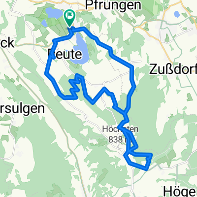
Lärchenweg 9, Illmensee nach Lärchenweg 9, Illmensee
A cycling route starting in Illmensee, Baden-Wurttemberg, Germany.
Overview
About this route
- 37 min
- Duration
- 22.1 km
- Distance
- 308 m
- Ascent
- 308 m
- Descent
- 35.8 km/h
- Avg. speed
- ---
- Max. altitude
Route quality
Waytypes & surfaces along the route
Waytypes
Road
8.4 km
(38 %)
Quiet road
5.3 km
(24 %)
Surfaces
Paved
22.1 km
(100 %)
Asphalt
22.1 km
(100 %)
Continue with Bikemap
Use, edit, or download this cycling route
You would like to ride Lärchenweg 9, Illmensee nach Lärchenweg 9, Illmensee or customize it for your own trip? Here is what you can do with this Bikemap route:
Free features
- Save this route as favorite or in collections
- Copy & plan your own version of this route
- Sync your route with Garmin or Wahoo
Premium features
Free trial for 3 days, or one-time payment. More about Bikemap Premium.
- Navigate this route on iOS & Android
- Export a GPX / KML file of this route
- Create your custom printout (try it for free)
- Download this route for offline navigation
Discover more Premium features.
Get Bikemap PremiumFrom our community
Other popular routes starting in Illmensee
 Lange Ausfahrt vom 1. Oktober 12:49
- Distance
- 42.7 km
- Ascent
- 345 m
- Descent
- 346 m
- Location
- Illmensee, Baden-Wurttemberg, Germany
 AH Heiligenberg Route ohne Friedwald
- Distance
- 30.7 km
- Ascent
- 49 m
- Descent
- 118 m
- Location
- Illmensee, Baden-Wurttemberg, Germany
 Illmensee - Glashütte MTB
- Distance
- 24.2 km
- Ascent
- 0 m
- Descent
- 0 m
- Location
- Illmensee, Baden-Wurttemberg, Germany
 Lärchenweg 9, Illmensee nach Lärchenweg 9, Illmensee
- Distance
- 22.1 km
- Ascent
- 308 m
- Descent
- 308 m
- Location
- Illmensee, Baden-Wurttemberg, Germany
 150830 Illmensee Rotachtal Schönemühle Deggenhauser Tal
- Distance
- 36.4 km
- Ascent
- 243 m
- Descent
- 246 m
- Location
- Illmensee, Baden-Wurttemberg, Germany
 Aufnahme vom 7. August 12:56
- Distance
- 39.4 km
- Ascent
- 212 m
- Descent
- 211 m
- Location
- Illmensee, Baden-Wurttemberg, Germany
 Illmensee - Heuneberg und zurück
- Distance
- 101.3 km
- Ascent
- 551 m
- Descent
- 551 m
- Location
- Illmensee, Baden-Wurttemberg, Germany
 SALEMERRUNDE 10 04 16
- Distance
- 56.2 km
- Ascent
- 407 m
- Descent
- 407 m
- Location
- Illmensee, Baden-Wurttemberg, Germany
Open it in the app