

Verbessererte Vers. der Strecke HIG-Geisl.-Heuthen-Werdingshausen-Flinsbg.-u.z.
A cycling route starting in Heilbad Heiligenstadt, Thuringia, Germany.
Overview
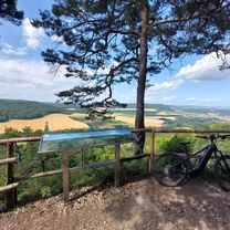
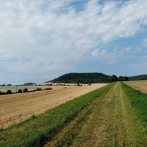
About this route
Improved version of the route HIG-Geisl.-Heuthen-Werdingshausen-Flinsbg.-u.z.: The section between Kalteneber and the Holzweg through the forest is only sensible after a longer dry spell. The forest paths are unpaved in places and very muddy after rainfall!
- -:--
- Duration
- 28.6 km
- Distance
- 438 m
- Ascent
- 438 m
- Descent
- ---
- Avg. speed
- ---
- Max. altitude
Route quality
Waytypes & surfaces along the route
Waytypes
Track
16.6 km
(58 %)
Road
3.4 km
(12 %)
Surfaces
Paved
7.4 km
(26 %)
Unpaved
14.6 km
(51 %)
Gravel
11.5 km
(40 %)
Asphalt
7.2 km
(25 %)
Route highlights
Points of interest along the route
Point of interest after 15.5 km
Allee von Schwedischen Maulbeerbäumen aus dem Jahr 1910
Continue with Bikemap
Use, edit, or download this cycling route
You would like to ride Verbessererte Vers. der Strecke HIG-Geisl.-Heuthen-Werdingshausen-Flinsbg.-u.z. or customize it for your own trip? Here is what you can do with this Bikemap route:
Free features
- Save this route as favorite or in collections
- Copy & plan your own version of this route
- Sync your route with Garmin or Wahoo
Premium features
Free trial for 3 days, or one-time payment. More about Bikemap Premium.
- Navigate this route on iOS & Android
- Export a GPX / KML file of this route
- Create your custom printout (try it for free)
- Download this route for offline navigation
Discover more Premium features.
Get Bikemap PremiumFrom our community
Other popular routes starting in Heilbad Heiligenstadt
 Aussichtspunktrunde am Vormittag
- Distance
- 29.1 km
- Ascent
- 973 m
- Descent
- 1,030 m
- Location
- Heilbad Heiligenstadt, Thuringia, Germany
 HIG Dieterode HIG vom 19. Juni 14:50
- Distance
- 31.3 km
- Ascent
- 331 m
- Descent
- 351 m
- Location
- Heilbad Heiligenstadt, Thuringia, Germany
 Saisonstart 23 kleine Eic Runde
- Distance
- 42.6 km
- Ascent
- 650 m
- Descent
- 613 m
- Location
- Heilbad Heiligenstadt, Thuringia, Germany
 Melli25_T3
- Distance
- 45.2 km
- Ascent
- 517 m
- Descent
- 397 m
- Location
- Heilbad Heiligenstadt, Thuringia, Germany
 Heilbad Heiligenstadt Cycling
- Distance
- 61 km
- Ascent
- 245 m
- Descent
- 333 m
- Location
- Heilbad Heiligenstadt, Thuringia, Germany
 Verbessererte Vers. der Strecke HIG-Geisl.-Heuthen-Werdingshausen-Flinsbg.-u.z.
- Distance
- 28.6 km
- Ascent
- 438 m
- Descent
- 438 m
- Location
- Heilbad Heiligenstadt, Thuringia, Germany
 HIG- Steinheuterr.-Schachtebich-Rohrbg.-Vogelsang- Bischh.-Siemerode- Mengelrode-HIG
- Distance
- 31.4 km
- Ascent
- 289 m
- Descent
- 289 m
- Location
- Heilbad Heiligenstadt, Thuringia, Germany
 mini runde vorm regen
- Distance
- 16.8 km
- Ascent
- 375 m
- Descent
- 374 m
- Location
- Heilbad Heiligenstadt, Thuringia, Germany
Open it in the app