

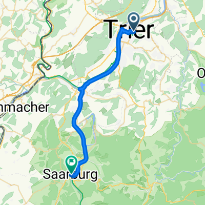
Tour der Leiden ;-)
A cycling route starting in Trier, Rhineland-Palatinate, Germany.
Overview
About this route
hast Du super gemacht Anna!
- -:--
- Duration
- 90.5 km
- Distance
- 1,226 m
- Ascent
- 1,037 m
- Descent
- ---
- Avg. speed
- 703 m
- Max. altitude
Route quality
Waytypes & surfaces along the route
Waytypes
Busy road
50 km
(55 %)
Quiet road
13.9 km
(15 %)
Surfaces
Paved
79.9 km
(88 %)
Unpaved
4 km
(4 %)
Asphalt
73.3 km
(81 %)
Paved (undefined)
5.7 km
(6 %)
Continue with Bikemap
Use, edit, or download this cycling route
You would like to ride Tour der Leiden ;-) or customize it for your own trip? Here is what you can do with this Bikemap route:
Free features
- Save this route as favorite or in collections
- Copy & plan your own version of this route
- Split it into stages to create a multi-day tour
- Sync your route with Garmin or Wahoo
Premium features
Free trial for 3 days, or one-time payment. More about Bikemap Premium.
- Navigate this route on iOS & Android
- Export a GPX / KML file of this route
- Create your custom printout (try it for free)
- Download this route for offline navigation
Discover more Premium features.
Get Bikemap PremiumFrom our community
Other popular routes starting in Trier
 2. Etappe - Graf-Siegfried-Straße, Saarburg nach Heinertstraße, Mettlach
- Distance
- 24.3 km
- Ascent
- 166 m
- Descent
- 139 m
- Location
- Trier, Rhineland-Palatinate, Germany
 Trier - Bernkastel
- Distance
- 66 km
- Ascent
- 182 m
- Descent
- 220 m
- Location
- Trier, Rhineland-Palatinate, Germany
 Tour der Leiden ;-)
- Distance
- 90.5 km
- Ascent
- 1,226 m
- Descent
- 1,037 m
- Location
- Trier, Rhineland-Palatinate, Germany
 Trier - Ehrang - Euren - Trier
- Distance
- 34.9 km
- Ascent
- 506 m
- Descent
- 508 m
- Location
- Trier, Rhineland-Palatinate, Germany
 Trier-Mariahof-Roscheid und zurück
- Distance
- 28.2 km
- Ascent
- 365 m
- Descent
- 297 m
- Location
- Trier, Rhineland-Palatinate, Germany
 Trier - Koblenz
- Distance
- 190.9 km
- Ascent
- 267 m
- Descent
- 331 m
- Location
- Trier, Rhineland-Palatinate, Germany
 Moselradweg
- Distance
- 150 km
- Ascent
- 792 m
- Descent
- 851 m
- Location
- Trier, Rhineland-Palatinate, Germany
 2018 Trier - Luxemburg - Laon - Amiens - Caen - Le Mont-Saint-Michel - St.Malo - Brest - Nantes
- Distance
- 1,877.5 km
- Ascent
- 1,181 m
- Descent
- 1,299 m
- Location
- Trier, Rhineland-Palatinate, Germany
Open it in the app