TT_U-E09
A cycling route starting in Aigle, Canton of Vaud, Switzerland.
Overview
About this route
- -:--
- Duration
- 45.8 km
- Distance
- 1,581 m
- Ascent
- 983 m
- Descent
- ---
- Avg. speed
- ---
- Max. altitude
Route quality
Waytypes & surfaces along the route
Waytypes
Road
0.5 km
(1 %)
Living street
0.5 km
(1 %)
Undefined
44.9 km
(98 %)
Surfaces
Paved
36.6 km
(80 %)
Asphalt
36.6 km
(80 %)
Undefined
9.2 km
(20 %)
Continue with Bikemap
Use, edit, or download this cycling route
You would like to ride TT_U-E09 or customize it for your own trip? Here is what you can do with this Bikemap route:
Free features
- Save this route as favorite or in collections
- Copy & plan your own version of this route
- Sync your route with Garmin or Wahoo
Premium features
Free trial for 3 days, or one-time payment. More about Bikemap Premium.
- Navigate this route on iOS & Android
- Export a GPX / KML file of this route
- Create your custom printout (try it for free)
- Download this route for offline navigation
Discover more Premium features.
Get Bikemap PremiumFrom our community
Other popular routes starting in Aigle
Corbeyer- tour d'Aï- Via Ferrata- Distance
- 16.2 km
- Ascent
- 1,374 m
- Descent
- 1,123 m
- Location
- Aigle, Canton of Vaud, Switzerland
2014-T12-Aigle-Moudon- Distance
- 51.8 km
- Ascent
- 668 m
- Descent
- 552 m
- Location
- Aigle, Canton of Vaud, Switzerland
47° Nord Tour de Suisse Etappe 4- Distance
- 63.7 km
- Ascent
- 1,423 m
- Descent
- 938 m
- Location
- Aigle, Canton of Vaud, Switzerland
Aigle 1/7- Distance
- 169.5 km
- Ascent
- 2,802 m
- Descent
- 2,015 m
- Location
- Aigle, Canton of Vaud, Switzerland
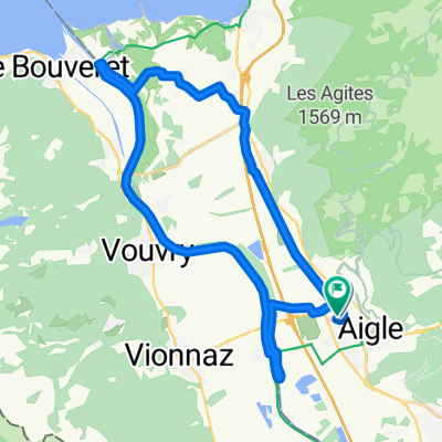
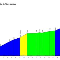
Etape 3 : Aigle - Gstaad (Tour de Suisse, Aramis) 40 km- Distance
- 39.7 km
- Ascent
- 1,192 m
- Descent
- 601 m
- Location
- Aigle, Canton of Vaud, Switzerland
Aigle-VD-BE-FR : Chemins de traverse pour cols et D+ en pagaille- Distance
- 204.6 km
- Ascent
- 4,602 m
- Descent
- 4,602 m
- Location
- Aigle, Canton of Vaud, Switzerland
Aigle-Col du Lein-Col du sanetsch-Aigle- Distance
- 140.1 km
- Ascent
- 3,382 m
- Descent
- 3,381 m
- Location
- Aigle, Canton of Vaud, Switzerland
Complete Alpine Tour- Distance
- 506.5 km
- Ascent
- 5,081 m
- Descent
- 5,093 m
- Location
- Aigle, Canton of Vaud, Switzerland
Open it in the app


