Premium Badge Download on the App Store Get it on Google Play Turn-by-turn Navigation Offline Maps Bike Type Optimized Routing Premium Maps Custom Bike Computer Export Routes Route Previews Fall Detection Premium Support

Cycling Route in Most, Ústecký kraj, Czechia

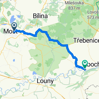
Z Mostu Českým středohořím

1
Open this route in the Bikemap app

Open this route in the Bikemap app

Open this route in Bikemap Web

Open this route in Bikemap Web

59 km
Distance
906 m
Ascent
792 m
Descent
-:-- h
Duration
-- km/h
Avg. Speed
697 m
Max. Elevation

About This Route

Cesta začíná v Mostě, pokračuje přes Hrobčice do Červeného Újezda a dále stoupání na chráněné území Hradišťanská louka. Potom dolů do obce Kostomlaty a další stoupání do Lukova. Potom návrat zpět do Mostu. Jedná se o příjemnou projížďku po málo frekventovaných silnicích a po lesních cestách.

This cycling route is ideal for: MTB

You will cycle on the following surfaces: Paved Unpaved Gravel

Customize this cycling route with the Bikemap route planner.

Make it yours!

Did you know? You can use this route as a template in our cycling route planner if you don't wish to start from scratch. Customize it based on your needs to plan your perfect cycling tour.

Open it in the app