

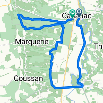
Orleix Cycling
A cycling route starting in Orleix, Occitanie, France.
Overview
About this route
- -:--
- Duration
- 17.6 km
- Distance
- 279 m
- Ascent
- 204 m
- Descent
- ---
- Avg. speed
- ---
- Max. altitude

Route quality
Waytypes & surfaces along the route
Waytypes
Busy road
11.4 km
(65 %)
Road
3.6 km
(20 %)
Surfaces
Paved
9.7 km
(55 %)
Asphalt
9.7 km
(55 %)
Undefined
7.8 km
(45 %)
Continue with Bikemap
Use, edit, or download this cycling route
You would like to ride Orleix Cycling or customize it for your own trip? Here is what you can do with this Bikemap route:
Free features
- Save this route as favorite or in collections
- Copy & plan your own version of this route
- Sync your route with Garmin or Wahoo
Premium features
Free trial for 3 days, or one-time payment. More about Bikemap Premium.
- Navigate this route on iOS & Android
- Export a GPX / KML file of this route
- Create your custom printout (try it for free)
- Download this route for offline navigation
Discover more Premium features.
Get Bikemap PremiumFrom our community
Other popular routes starting in Orleix
 Pouya
Pouya- Distance
- 16.3 km
- Ascent
- 21 m
- Descent
- 164 m
- Location
- Orleix, Occitanie, France
 Tarbes - Col de
- Distance
- 121 km
- Ascent
- 2,587 m
- Descent
- 1,696 m
- Location
- Orleix, Occitanie, France
 De D5, Hourc à 11 Chemin du Hourquillet, Lespouey
- Distance
- 16.3 km
- Ascent
- 743 m
- Descent
- 676 m
- Location
- Orleix, Occitanie, France
 Маршрут в Orleix
- Distance
- 3.1 km
- Ascent
- 12 m
- Descent
- 11 m
- Location
- Orleix, Occitanie, France
 De Route du Pays des Coteaux à Route du Pays des Coteaux
- Distance
- 14.9 km
- Ascent
- 211 m
- Descent
- 246 m
- Location
- Orleix, Occitanie, France
 8 Route des Crêtes, Bouilh-Péreuilh à 8 Route des Crêtes, Bouilh-Péreuilh
- Distance
- 26.1 km
- Ascent
- 681 m
- Descent
- 680 m
- Location
- Orleix, Occitanie, France
 8 Route des Crêtes, Bouilh-Péreuilh à 8 Route des Crêtes, Bouilh-Péreuilh
- Distance
- 51.1 km
- Ascent
- 416 m
- Descent
- 416 m
- Location
- Orleix, Occitanie, France
 Pouyastruc-Capvern1
- Distance
- 89.2 km
- Ascent
- 684 m
- Descent
- 542 m
- Location
- Orleix, Occitanie, France
Open it in the app