

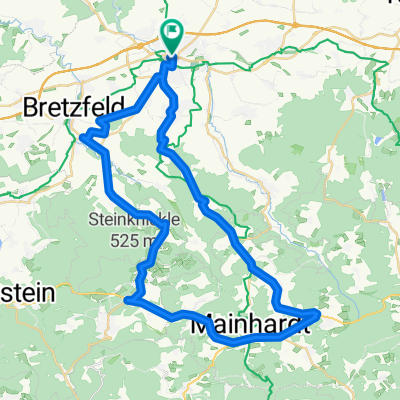
Pfedelbach-01
A cycling route starting in Öhringen, Baden-Wurttemberg, Germany.
Overview
About this route
- -:--
- Duration
- 41.9 km
- Distance
- 585 m
- Ascent
- 583 m
- Descent
- ---
- Avg. speed
- ---
- Max. altitude

Route quality
Waytypes & surfaces along the route
Waytypes
Track
22.6 km
(54 %)
Quiet road
10.9 km
(26 %)
Surfaces
Paved
19.7 km
(47 %)
Unpaved
17.6 km
(42 %)
Asphalt
17.2 km
(41 %)
Gravel
11.3 km
(27 %)
Continue with Bikemap
Use, edit, or download this cycling route
You would like to ride Pfedelbach-01 or customize it for your own trip? Here is what you can do with this Bikemap route:
Free features
- Save this route as favorite or in collections
- Copy & plan your own version of this route
- Sync your route with Garmin or Wahoo
Premium features
Free trial for 3 days, or one-time payment. More about Bikemap Premium.
- Navigate this route on iOS & Android
- Export a GPX / KML file of this route
- Create your custom printout (try it for free)
- Download this route for offline navigation
Discover more Premium features.
Get Bikemap PremiumFrom our community
Other popular routes starting in Öhringen
 Kochertour
- Distance
- 83.2 km
- Ascent
- 328 m
- Descent
- 330 m
- Location
- Öhringen, Baden-Wurttemberg, Germany
 Öhringen Sindringen Ohrnberg
- Distance
- 31.1 km
- Ascent
- 275 m
- Descent
- 261 m
- Location
- Öhringen, Baden-Wurttemberg, Germany
 Pfedelbach-01
- Distance
- 41.9 km
- Ascent
- 585 m
- Descent
- 583 m
- Location
- Öhringen, Baden-Wurttemberg, Germany
 kurze Runde bei 34 C
- Distance
- 19.4 km
- Ascent
- 281 m
- Descent
- 297 m
- Location
- Öhringen, Baden-Wurttemberg, Germany
 Rundtour Öhringen-Frohnfalls-Öhringen
- Distance
- 24.8 km
- Ascent
- 300 m
- Descent
- 299 m
- Location
- Öhringen, Baden-Wurttemberg, Germany
 Ohrntalrunde
- Distance
- 30.1 km
- Ascent
- 332 m
- Descent
- 332 m
- Location
- Öhringen, Baden-Wurttemberg, Germany
 Öhringen - Unterheimbach - Mainhardt - Gleichen - Heuberg - Öhringen
- Distance
- 49.6 km
- Ascent
- 484 m
- Descent
- 485 m
- Location
- Öhringen, Baden-Wurttemberg, Germany
 Im Möhriger Feld 2, Öhringen to Lindenallee 8, Öhringen
- Distance
- 6.3 km
- Ascent
- 92 m
- Descent
- 96 m
- Location
- Öhringen, Baden-Wurttemberg, Germany
Open it in the app