

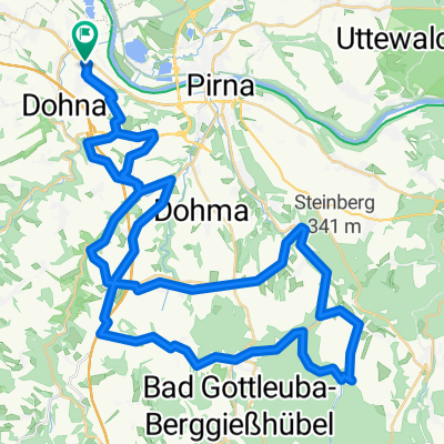
29. Heidenauer RTF - 150 km NEU CLONED FROM ROUTE 684918
A cycling route starting in Heidenau, Saxony, Germany.
Overview
About this route
18.09.2010 Start: 09-10.30 Uhr
Pestalozzi-Gymnasium Heidenau
KP Stolpen liegt in Stolpen-Zscheppa (Nähe vom Bad), KP Ulbersdorf an Gasthof "Almenhof", KP Cunnersdorf am/hinter dem Bad, danach ca. 6 km durch Landesforst nach Rosenthal, KP Berggießhübel auf Bad-Parkplatz
7 Anstiege: vom Polenztal nach Hohnstein, von Ehrenberg nach Krumhermsdorf, aus dem Sebnitztal nach Lichtenhain, von Krippen nach Papstdorf, im Forst vom Abzw. Fuchsteich nach Rosenthal, aus dem Bielatal von Rosenthal nach Raum, aus Gottleubatal nach Breitenau (Schusterberg!)
8 Abfahrten: nach Pirna hinein, Polenztal, in Sebnitz, von Ulbersdorf ins Sebnitztal, von Altenhain nach Bad Schandau, nach Rosenthal hinein, von Oelsen ins Gottleubatal, von Breitenau bis Gersdorf, sowie von Großsedlitz nach Heidenau
9 Täler: Wesenitztal, Polenztal, Sebnitztal, Elbtal, Bielatal, Gottleubatal, Bahratal, Bahretal, Seidewitztal
für sportliche Erwachsene geeignet, Rennrad von Vorteil
- -:--
- Duration
- 147.3 km
- Distance
- 1,422 m
- Ascent
- 1,422 m
- Descent
- ---
- Avg. speed
- ---
- Max. altitude

Route quality
Waytypes & surfaces along the route
Waytypes
Road
66.3 km
(45 %)
Track
22.1 km
(15 %)
Surfaces
Paved
112 km
(76 %)
Unpaved
8.8 km
(6 %)
Asphalt
106.1 km
(72 %)
Paved (undefined)
5.9 km
(4 %)
Continue with Bikemap
Use, edit, or download this cycling route
You would like to ride 29. Heidenauer RTF - 150 km NEU CLONED FROM ROUTE 684918 or customize it for your own trip? Here is what you can do with this Bikemap route:
Free features
- Save this route as favorite or in collections
- Copy & plan your own version of this route
- Split it into stages to create a multi-day tour
- Sync your route with Garmin or Wahoo
Premium features
Free trial for 3 days, or one-time payment. More about Bikemap Premium.
- Navigate this route on iOS & Android
- Export a GPX / KML file of this route
- Create your custom printout (try it for free)
- Download this route for offline navigation
Discover more Premium features.
Get Bikemap PremiumFrom our community
Other popular routes starting in Heidenau
 33. Heidenauer RTF 20.09.2014 - 60km -
- Distance
- 56.2 km
- Ascent
- 655 m
- Descent
- 656 m
- Location
- Heidenau, Saxony, Germany
 Morgendliche Fahrradtour mit Michi
- Distance
- 55.7 km
- Ascent
- 436 m
- Descent
- 430 m
- Location
- Heidenau, Saxony, Germany
 30. Heidenauer RTF 17.09.2011 - 80km NEU
- Distance
- 71.1 km
- Ascent
- 886 m
- Descent
- 886 m
- Location
- Heidenau, Saxony, Germany
 30. Heidenauer RTF 17.09.2011 - 150 km - NEU
- Distance
- 145.4 km
- Ascent
- 1,284 m
- Descent
- 1,284 m
- Location
- Heidenau, Saxony, Germany
 Schönwetterrunde
- Distance
- 115.9 km
- Ascent
- 448 m
- Descent
- 443 m
- Location
- Heidenau, Saxony, Germany
 008_Mitteldeutschlandtour2010_Tag08_Dresden-Kirschau
- Distance
- 70.2 km
- Ascent
- 574 m
- Descent
- 431 m
- Location
- Heidenau, Saxony, Germany
 Pirnaer Straße nach Pirnaer Straße
- Distance
- 54 km
- Ascent
- 226 m
- Descent
- 274 m
- Location
- Heidenau, Saxony, Germany
 30. Heidenauer RTF 17.09.2011 - 120 km - NEU
- Distance
- 121.7 km
- Ascent
- 996 m
- Descent
- 996 m
- Location
- Heidenau, Saxony, Germany
Open it in the app