

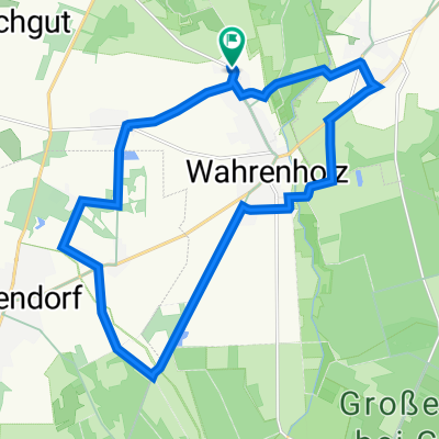
runtur Wahrenholz über Schönewörde am kanal
A cycling route starting in Wahrenholz, Lower Saxony, Germany.
Overview
About this route
Meine täkliche runde nach feierabend zum endspannen
- -:--
- Duration
- 18.5 km
- Distance
- 37 m
- Ascent
- 39 m
- Descent
- ---
- Avg. speed
- ---
- Max. altitude
Route quality
Waytypes & surfaces along the route
Waytypes
Track
10.2 km
(55 %)
Access road
4 km
(22 %)
Surfaces
Paved
4.9 km
(27 %)
Unpaved
11.9 km
(65 %)
Gravel
5.6 km
(30 %)
Loose gravel
3.9 km
(21 %)
Continue with Bikemap
Use, edit, or download this cycling route
You would like to ride runtur Wahrenholz über Schönewörde am kanal or customize it for your own trip? Here is what you can do with this Bikemap route:
Free features
- Save this route as favorite or in collections
- Copy & plan your own version of this route
- Sync your route with Garmin or Wahoo
Premium features
Free trial for 3 days, or one-time payment. More about Bikemap Premium.
- Navigate this route on iOS & Android
- Export a GPX / KML file of this route
- Create your custom printout (try it for free)
- Download this route for offline navigation
Discover more Premium features.
Get Bikemap PremiumFrom our community
Other popular routes starting in Wahrenholz
 ElmTour
- Distance
- 173.5 km
- Ascent
- 503 m
- Descent
- 502 m
- Location
- Wahrenholz, Lower Saxony, Germany
 Fahrradrallye 2022
- Distance
- 28.8 km
- Ascent
- 68 m
- Descent
- 66 m
- Location
- Wahrenholz, Lower Saxony, Germany
 Radtour Rund um Ise und Elbe-Seitenkanal - M. Wiescher
- Distance
- 40.6 km
- Ascent
- 178 m
- Descent
- 177 m
- Location
- Wahrenholz, Lower Saxony, Germany
 runtur Wahrenholz über Schönewörde am kanal
- Distance
- 18.5 km
- Ascent
- 37 m
- Descent
- 39 m
- Location
- Wahrenholz, Lower Saxony, Germany
 Radwandertag 2023_lang_version_1
- Distance
- 23.3 km
- Ascent
- 90 m
- Descent
- 93 m
- Location
- Wahrenholz, Lower Saxony, Germany
 Radwandertag 2024_lang
- Distance
- 18.8 km
- Ascent
- 41 m
- Descent
- 41 m
- Location
- Wahrenholz, Lower Saxony, Germany
 Wahrenholzer Runde
- Distance
- 37.1 km
- Ascent
- 82 m
- Descent
- 82 m
- Location
- Wahrenholz, Lower Saxony, Germany
 Gifhorn Skagen Stralsund
- Distance
- 1,667.4 km
- Ascent
- 3,019 m
- Descent
- 3,077 m
- Location
- Wahrenholz, Lower Saxony, Germany
Open it in the app