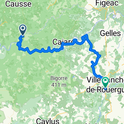
ETAPE N°04
A cycling route starting in Cajarc, Occitanie, France.
Overview
About this route
- -:--
- Duration
- 79.4 km
- Distance
- 824 m
- Ascent
- 695 m
- Descent
- ---
- Avg. speed
- ---
- Max. altitude
Route quality
Waytypes & surfaces along the route
Waytypes
Road
50 km
(63 %)
Quiet road
24.6 km
(31 %)
Surfaces
Paved
36.5 km
(46 %)
Unpaved
1.6 km
(2 %)
Asphalt
36.5 km
(46 %)
Gravel
0.8 km
(1 %)
Route highlights
Points of interest along the route
Point of interest after 58 km
ÉTANG DE CANTARANNE
Point of interest after 61.9 km
CORDE-SUR-CIEL
Point of interest after 79.3 km
RESERVOIRE DE FONROGUE
Point of interest after 79.4 km
CATHEDRALE ALBI
Continue with Bikemap
Use, edit, or download this cycling route
You would like to ride ETAPE N°04 or customize it for your own trip? Here is what you can do with this Bikemap route:
Free features
- Save this route as favorite or in collections
- Copy & plan your own version of this route
- Sync your route with Garmin or Wahoo
Premium features
Free trial for 3 days, or one-time payment. More about Bikemap Premium.
- Navigate this route on iOS & Android
- Export a GPX / KML file of this route
- Create your custom printout (try it for free)
- Download this route for offline navigation
Discover more Premium features.
Get Bikemap PremiumFrom our community
Other popular routes starting in Cajarc
- LePuy-Pamplona Etappe 06 Cajarc Cahors
- Distance
- 50.5 km
- Ascent
- 290 m
- Descent
- 312 m
- Location
- Cajarc, Occitanie, France
- Dordogne 20130712
- Distance
- 66.7 km
- Ascent
- 572 m
- Descent
- 486 m
- Location
- Cajarc, Occitanie, France
- Camboulan_Tour_02
- Distance
- 21.7 km
- Ascent
- 324 m
- Descent
- 322 m
- Location
- Cajarc, Occitanie, France
- ETAPE N°04
- Distance
- 79.4 km
- Ascent
- 824 m
- Descent
- 695 m
- Location
- Cajarc, Occitanie, France
- Limogne en Quercy - Durfort-Lacapelette - St. Martin
- Distance
- 95.3 km
- Ascent
- 1,122 m
- Descent
- 1,361 m
- Location
- Cajarc, Occitanie, France
- TDF12 68k Rocamadour
- Distance
- 67.2 km
- Ascent
- 1,230 m
- Descent
- 1,115 m
- Location
- Cajarc, Occitanie, France
- Vallée du Lot et du Celé
- Distance
- 103.6 km
- Ascent
- 472 m
- Descent
- 472 m
- Location
- Cajarc, Occitanie, France
- Od Dordogne do Provence 4.etapa
- Distance
- 77.2 km
- Ascent
- 849 m
- Descent
- 740 m
- Location
- Cajarc, Occitanie, France
Open it in the app