
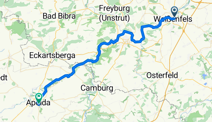
Weißenfels-Naumburg-Apolda
A cycling route starting in Weißenfels, Saxony-Anhalt, Germany.
Overview
About this route
Tour auf dem Saale- und Ilmtal-Radweg, landschaflich und historisch schön, teiweise anspruchsvoll. Eine meine Lieblingstouren.
wieder mal gefahren am 17.Juni 2010
- -:--
- Duration
- 53.7 km
- Distance
- 223 m
- Ascent
- 137 m
- Descent
- ---
- Avg. speed
- ---
- Avg. speed

Route quality
Waytypes & surfaces along the route
Waytypes
Cycleway
13.9 km
(26 %)
Quiet road
13.9 km
(26 %)
Surfaces
Paved
48.7 km
(91 %)
Unpaved
1.9 km
(4 %)
Asphalt
46.7 km
(87 %)
Gravel
1.4 km
(3 %)
Route highlights
Points of interest along the route
Point of interest after 3.1 km
Single-Trail Fußweg-Aufstieg mit Behinderten-Rampe
Point of interest after 27.3 km
Einstieg in den Weinberg Platten und Schotterpiste 14% Steigung
Point of interest after 28.5 km
Ausfahrt asus dem Weinberg
Point of interest after 33.2 km
Brücke immer noch im Bau seit Sommer 2009 bis April 2011
Point of interest after 33.4 km
Wald und Wiesenpiste ziemlich anspruchsvoll
Continue with Bikemap
Use, edit, or download this cycling route
You would like to ride Weißenfels-Naumburg-Apolda or customize it for your own trip? Here is what you can do with this Bikemap route:
Free features
- Save this route as favorite or in collections
- Copy & plan your own version of this route
- Sync your route with Garmin or Wahoo
Premium features
Free trial for 3 days, or one-time payment. More about Bikemap Premium.
- Navigate this route on iOS & Android
- Export a GPX / KML file of this route
- Create your custom printout (try it for free)
- Download this route for offline navigation
Discover more Premium features.
Get Bikemap PremiumFrom our community
Other popular routes starting in Weißenfels
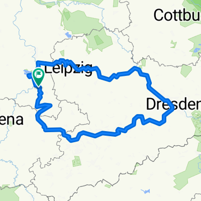
 Weißenfels-Leipzig
- Distance
- 51.2 km
- Ascent
- 149 m
- Descent
- 104 m
- Location
- Weißenfels, Saxony-Anhalt, Germany
 Weißensfels - Bad Kösen
- Distance
- 30.8 km
- Ascent
- 119 m
- Descent
- 102 m
- Location
- Weißenfels, Saxony-Anhalt, Germany
 SRW_Etappe7
- Distance
- 68.8 km
- Ascent
- 135 m
- Descent
- 143 m
- Location
- Weißenfels, Saxony-Anhalt, Germany
 WSF 002: Weißenfelsrunde 2
- Distance
- 93.3 km
- Ascent
- 347 m
- Descent
- 347 m
- Location
- Weißenfels, Saxony-Anhalt, Germany
 Südfeldsee und Saaleradweg
- Distance
- 28.9 km
- Ascent
- 167 m
- Descent
- 165 m
- Location
- Weißenfels, Saxony-Anhalt, Germany
 12 Apostelbrücke
- Distance
- 119.4 km
- Ascent
- 360 m
- Descent
- 360 m
- Location
- Weißenfels, Saxony-Anhalt, Germany
 D11 cheat Weissenfels bis Grafenhainichen
- Distance
- 102.7 km
- Ascent
- 130 m
- Descent
- 136 m
- Location
- Weißenfels, Saxony-Anhalt, Germany
 Runde2025
- Distance
- 487.1 km
- Ascent
- 3,574 m
- Descent
- 3,573 m
- Location
- Weißenfels, Saxony-Anhalt, Germany
Open it in the app