

Elsass-Radtour Tag 4
A cycling route starting in Ottmarsheim, Grand Est, France.
Overview
About this route
Part of a tour through Alsace
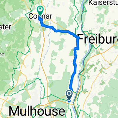
Stage 4: Ottmarsheim - Guebwiller
- -:--
- Duration
- 40.9 km
- Distance
- 102 m
- Ascent
- 35 m
- Descent
- ---
- Avg. speed
- ---
- Max. altitude
Route highlights
Points of interest along the route
Point of interest after 20.1 km
St.-Georges
Point of interest after 30.4 km
Pause vor dem geschlossenen Freilichtmuseum
Point of interest after 35.1 km
Pause im Best Western Bollwiller
Accommodation after 40.9 km
Hotel de l´Ange
Continue with Bikemap
Use, edit, or download this cycling route
You would like to ride Elsass-Radtour Tag 4 or customize it for your own trip? Here is what you can do with this Bikemap route:
Free features
- Save this route as favorite or in collections
- Copy & plan your own version of this route
- Sync your route with Garmin or Wahoo
Premium features
Free trial for 3 days, or one-time payment. More about Bikemap Premium.
- Navigate this route on iOS & Android
- Export a GPX / KML file of this route
- Create your custom printout (try it for free)
- Download this route for offline navigation
Discover more Premium features.
Get Bikemap PremiumFrom our community
Other popular routes starting in Ottmarsheim
 Ottmarsheim-Wien(3)
- Distance
- 1,064.9 km
- Ascent
- 786 m
- Descent
- 818 m
- Location
- Ottmarsheim, Grand Est, France
 BFA D07 Ottmarscheim - Colmar
- Distance
- 49.7 km
- Ascent
- 25 m
- Descent
- 54 m
- Location
- Ottmarsheim, Grand Est, France
 Route Edf, Оттмарсхайм до Schlesienstraße 19, Нойенбург-на-Рейне
- Distance
- 9.8 km
- Ascent
- 48 m
- Descent
- 44 m
- Location
- Ottmarsheim, Grand Est, France
 Grünhutte - Fesenheim - Zinken - Neuenburg
- Distance
- 51.5 km
- Ascent
- 54 m
- Descent
- 56 m
- Location
- Ottmarsheim, Grand Est, France
 eurovélo6-05
- Distance
- 217.3 km
- Ascent
- 254 m
- Descent
- 277 m
- Location
- Ottmarsheim, Grand Est, France
 Mulhouse
- Distance
- 14.3 km
- Ascent
- 35 m
- Descent
- 22 m
- Location
- Ottmarsheim, Grand Est, France
 Moulhouse - Baume les Dames
- Distance
- 122.9 km
- Ascent
- 384 m
- Descent
- 342 m
- Location
- Ottmarsheim, Grand Est, France
 Elsass-Radtour Tag 4
- Distance
- 40.9 km
- Ascent
- 102 m
- Descent
- 35 m
- Location
- Ottmarsheim, Grand Est, France
Open it in the app