

Panarotte via Kamauz
A cycling route starting in Levico Terme, Trentino-Alto Adige, Italy.
Overview
About this route
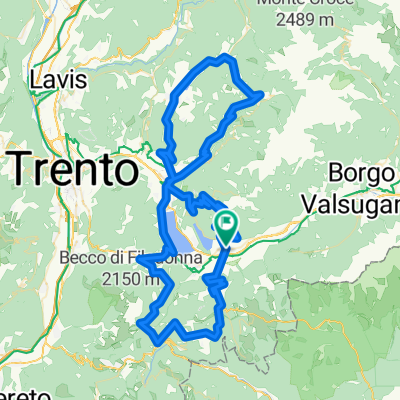
Start Levico Terme. Ascent via Pergine, Fersental to Kamauz on partially steep asphalt, then to Maso Stoaner on gravel path, continuing on a narrow trail to La Bassa, from there a short detour to Panarotta, before descending again into Fersental on a partially bumpy gravel track. From Pergine back to Levico via Tenna.
- -:--
- Duration
- 55.1 km
- Distance
- 1,721 m
- Ascent
- 1,722 m
- Descent
- ---
- Avg. speed
- ---
- Max. altitude
Continue with Bikemap
Use, edit, or download this cycling route
You would like to ride Panarotte via Kamauz or customize it for your own trip? Here is what you can do with this Bikemap route:
Free features
- Save this route as favorite or in collections
- Copy & plan your own version of this route
- Sync your route with Garmin or Wahoo
Premium features
Free trial for 3 days, or one-time payment. More about Bikemap Premium.
- Navigate this route on iOS & Android
- Export a GPX / KML file of this route
- Create your custom printout (try it for free)
- Download this route for offline navigation
Discover more Premium features.
Get Bikemap PremiumFrom our community
Other popular routes starting in Levico Terme
 Panarotte via Kamauz
- Distance
- 55.1 km
- Ascent
- 1,721 m
- Descent
- 1,722 m
- Location
- Levico Terme, Trentino-Alto Adige, Italy
 Passo Manghen-Passo Redebus
- Distance
- 113.3 km
- Ascent
- 2,765 m
- Descent
- 2,777 m
- Location
- Levico Terme, Trentino-Alto Adige, Italy
 Levico Terme 2018 - CX Bike / Gravel Bike: Levico Terme - Rifugio Panarotta
- Distance
- 42.6 km
- Ascent
- 1,516 m
- Descent
- 1,516 m
- Location
- Levico Terme, Trentino-Alto Adige, Italy
 Hotel Eden- Pannarotta
- Distance
- 16.3 km
- Ascent
- 1,308 m
- Descent
- 39 m
- Location
- Levico Terme, Trentino-Alto Adige, Italy
 22/08/2020 Da Località Pleina 5, Levico Terme a Località Pleina 5, Levico Terme
- Distance
- 29.5 km
- Ascent
- 343 m
- Descent
- 340 m
- Location
- Levico Terme, Trentino-Alto Adige, Italy
 Levico per i Laghi andata e ritorno
- Distance
- 18.8 km
- Ascent
- 190 m
- Descent
- 176 m
- Location
- Levico Terme, Trentino-Alto Adige, Italy
 1190hm - 59km Bedollo
- Distance
- 58.4 km
- Ascent
- 1,125 m
- Descent
- 1,122 m
- Location
- Levico Terme, Trentino-Alto Adige, Italy
 Levico - Levico
- Distance
- 110.5 km
- Ascent
- 2,698 m
- Descent
- 2,698 m
- Location
- Levico Terme, Trentino-Alto Adige, Italy
Open it in the app