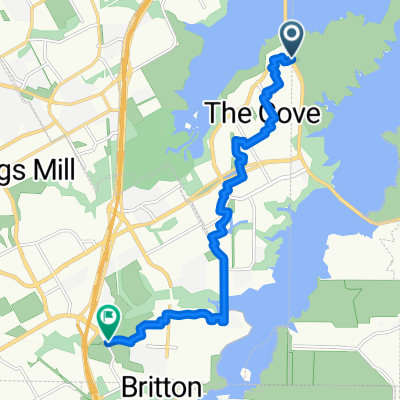
California Trail 1213, Grand Prairie to California Trail 1213, Grand Prairie
A cycling route starting in Cedar Hill, Texas, United States of America.
Overview
About this route
- 1 h 54 min
- Duration
- 26.9 km
- Distance
- 95 m
- Ascent
- 92 m
- Descent
- 14.1 km/h
- Avg. speed
- ---
- Avg. speed
Route photos
Route quality
Waytypes & surfaces along the route
Waytypes
Path
23.8 km
(88 %)
Busy road
1.5 km
(5 %)
Surfaces
Paved
26.5 km
(98 %)
Concrete
13.9 km
(52 %)
Paved (undefined)
11.9 km
(44 %)
Continue with Bikemap
Use, edit, or download this cycling route
You would like to ride California Trail 1213, Grand Prairie to California Trail 1213, Grand Prairie or customize it for your own trip? Here is what you can do with this Bikemap route:
Free features
- Save this route as favorite or in collections
- Copy & plan your own version of this route
- Sync your route with Garmin or Wahoo
Premium features
Free trial for 3 days, or one-time payment. More about Bikemap Premium.
- Navigate this route on iOS & Android
- Export a GPX / KML file of this route
- Create your custom printout (try it for free)
- Download this route for offline navigation
Discover more Premium features.
Get Bikemap PremiumFrom our community
Other popular routes starting in Cedar Hill
- Lake Ridge Parkway 1020, Cedar Hill to Paradise Court 2708, Cedar Hill
- Distance
- 16.6 km
- Ascent
- 97 m
- Descent
- 99 m
- Location
- Cedar Hill, Texas, United States of America
- Sea Harbor Drive 6935, Grand Prairie to Regatta Drive 6936, Grand Prairie
- Distance
- 12.7 km
- Ascent
- 63 m
- Descent
- 57 m
- Location
- Cedar Hill, Texas, United States of America
- ride through Grand Prairie
- Distance
- 17.6 km
- Ascent
- 20 m
- Descent
- 18 m
- Location
- Cedar Hill, Texas, United States of America
- Texas Plume Road 2850, Cedar Hill to High Valley Lane 1633, Cedar Hill
- Distance
- 19.7 km
- Ascent
- 105 m
- Descent
- 103 m
- Location
- Cedar Hill, Texas, United States of America
- Nautical Dr, Grand Prairie to 551 Miller Rd S, Mansfield
- Distance
- 10.1 km
- Ascent
- 14 m
- Descent
- 10 m
- Location
- Cedar Hill, Texas, United States of America
- Cedar Hill Cycling
- Distance
- 17.2 km
- Ascent
- 167 m
- Descent
- 163 m
- Location
- Cedar Hill, Texas, United States of America
- white rhino to white rock
- Distance
- 50.8 km
- Ascent
- 148 m
- Descent
- 224 m
- Location
- Cedar Hill, Texas, United States of America
- 467 Breezeway Ct, Cedar Hill to 2004 Valley View Dr, Cedar Hill
- Distance
- 37.9 km
- Ascent
- 351 m
- Descent
- 294 m
- Location
- Cedar Hill, Texas, United States of America
Open it in the app