

2022 - Ruta Nº 048
A cycling route starting in Valladolid, Castille and León, Spain.
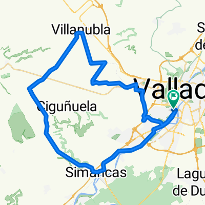
Overview
About this route
Renedo -Villabañez - (direction Olivares) - Villavaquerín turn-off) - Castrillo - Villafuerte - Amusquillo - Esguevillas - Piña - Renedo -Valladolid.
1st Climb: Canteras (1)
Average gradient 8.40 %
Distance 2.2 km.
2nd Climb: Páramo Rozas del Duero (1)
Average gradient 3.4 %
Length 3.6 km
3rd Climb: Páramo Villafuerte
Average gradient does not count
- -:--
- Duration
- 86.4 km
- Distance
- 629 m
- Ascent
- 630 m
- Descent
- ---
- Avg. speed
- 880 m
- Max. altitude

Route quality
Waytypes & surfaces along the route
Waytypes
Road
39.7 km
(46 %)
Quiet road
2.6 km
(3 %)
Surfaces
Paved
84.7 km
(98 %)
Asphalt
84.7 km
(98 %)
Undefined
1.7 km
(2 %)
Route highlights
Points of interest along the route
Point of interest after 10.9 km
Subida: Canteras (1) Pendiente media 8,40% Distancia 2,2 Km.
Point of interest after 21.3 km
Subida: Páramo Rozas del Duero (1) Pend media 3,4% Longitud 3,6 km
Point of interest after 43.9 km
Subida: Páramo Villafuerte Pendiente media no puntúa
Continue with Bikemap
Use, edit, or download this cycling route
You would like to ride 2022 - Ruta Nº 048 or customize it for your own trip? Here is what you can do with this Bikemap route:
Free features
- Save this route as favorite or in collections
- Copy & plan your own version of this route
- Split it into stages to create a multi-day tour
- Sync your route with Garmin or Wahoo
Premium features
Free trial for 3 days, or one-time payment. More about Bikemap Premium.
- Navigate this route on iOS & Android
- Export a GPX / KML file of this route
- Create your custom printout (try it for free)
- Download this route for offline navigation
Discover more Premium features.
Get Bikemap PremiumFrom our community
Other popular routes starting in Valladolid
 2022 - Ruta nº 063
- Distance
- 100.1 km
- Ascent
- 201 m
- Descent
- 199 m
- Location
- Valladolid, Castille and León, Spain
 vueltecilla mtb
- Distance
- 21.9 km
- Ascent
- 168 m
- Descent
- 159 m
- Location
- Valladolid, Castille and León, Spain
 2022 - Ruta nº 073
- Distance
- 98.2 km
- Ascent
- 439 m
- Descent
- 442 m
- Location
- Valladolid, Castille and León, Spain
 Ciguñuela
- Distance
- 16.3 km
- Ascent
- 200 m
- Descent
- 103 m
- Location
- Valladolid, Castille and León, Spain
 Zaratán - Villanubla - Simancas
- Distance
- 44.5 km
- Ascent
- 254 m
- Descent
- 255 m
- Location
- Valladolid, Castille and León, Spain
 Ruta: 20-Mayo-2018 - (PM - Amistad)
- Distance
- 92.8 km
- Ascent
- 435 m
- Descent
- 431 m
- Location
- Valladolid, Castille and León, Spain
 Circuito: VAREVITUCI
- Distance
- 37.6 km
- Ascent
- 303 m
- Descent
- 303 m
- Location
- Valladolid, Castille and León, Spain
 Orilla Rio
- Distance
- 40.3 km
- Ascent
- 115 m
- Descent
- 115 m
- Location
- Valladolid, Castille and León, Spain
Open it in the app