

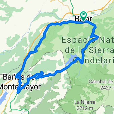
Garganta del oso, Bejar
A cycling route starting in Béjar, Castille and León, Spain.
Overview
About this route
- -:--
- Duration
- 12.8 km
- Distance
- 860 m
- Ascent
- 96 m
- Descent
- ---
- Avg. speed
- ---
- Max. altitude
Route quality
Waytypes & surfaces along the route
Waytypes
Track
9.3 km
(73 %)
Quiet road
1.8 km
(14 %)
Surfaces
Paved
0.9 km
(7 %)
Unpaved
6.8 km
(53 %)
Gravel
4.3 km
(34 %)
Sand
1.3 km
(10 %)
Continue with Bikemap
Use, edit, or download this cycling route
You would like to ride Garganta del oso, Bejar or customize it for your own trip? Here is what you can do with this Bikemap route:
Free features
- Save this route as favorite or in collections
- Copy & plan your own version of this route
- Sync your route with Garmin or Wahoo
Premium features
Free trial for 3 days, or one-time payment. More about Bikemap Premium.
- Navigate this route on iOS & Android
- Export a GPX / KML file of this route
- Create your custom printout (try it for free)
- Download this route for offline navigation
Discover more Premium features.
Get Bikemap PremiumFrom our community
Other popular routes starting in Béjar
 Extramadura-03: Bejar - La Alberca
- Distance
- 46.9 km
- Ascent
- 923 m
- Descent
- 821 m
- Location
- Béjar, Castille and León, Spain
 Béjar - Navacarros - San Bartolo - Sorihuela - Vallejera - Navacarros - Béjar
- Distance
- 29.8 km
- Ascent
- 698 m
- Descent
- 699 m
- Location
- Béjar, Castille and León, Spain
 Béjar 1
- Distance
- 82.2 km
- Ascent
- 2,185 m
- Descent
- 2,174 m
- Location
- Béjar, Castille and León, Spain
 BÉJAR - LA ALBERCA
- Distance
- 68.4 km
- Ascent
- 1,652 m
- Descent
- 1,457 m
- Location
- Béjar, Castille and León, Spain
 Béjar - Los Pinos - Candelario - Cancho la Muela - Llano Alto - Béjar
- Distance
- 32.2 km
- Ascent
- 742 m
- Descent
- 727 m
- Location
- Béjar, Castille and León, Spain
 Béjar - Baños de Montemayor - La Garganta - Candelario - Béjar
- Distance
- 37.2 km
- Ascent
- 741 m
- Descent
- 741 m
- Location
- Béjar, Castille and León, Spain
 Béjar- Ruta Heidi y Vía Verde
- Distance
- 77.6 km
- Ascent
- 1,425 m
- Descent
- 1,421 m
- Location
- Béjar, Castille and León, Spain
 Vuelta alrededor de Béjar
- Distance
- 41.7 km
- Ascent
- 526 m
- Descent
- 524 m
- Location
- Béjar, Castille and León, Spain
Open it in the app