
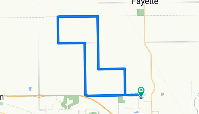
7125 E County Road 800 N, Brownsburg to 7095 E County Road 800 N, Brownsburg
A cycling route starting in Brownsburg, Indiana, United States.
Overview
About this route
- 1 h 1 min
- Duration
- 20.1 km
- Distance
- 33 m
- Ascent
- 32 m
- Descent
- 19.7 km/h
- Avg. speed
- ---
- Max. altitude
Route quality
Waytypes & surfaces along the route
Waytypes
Road
10.5 km
(52 %)
Quiet road
8.6 km
(43 %)
Continue with Bikemap
Use, edit, or download this cycling route
You would like to ride 7125 E County Road 800 N, Brownsburg to 7095 E County Road 800 N, Brownsburg or customize it for your own trip? Here is what you can do with this Bikemap route:
Free features
- Save this route as favorite or in collections
- Copy & plan your own version of this route
- Sync your route with Garmin or Wahoo
Premium features
Free trial for 3 days, or one-time payment. More about Bikemap Premium.
- Navigate this route on iOS & Android
- Export a GPX / KML file of this route
- Create your custom printout (try it for free)
- Download this route for offline navigation
Discover more Premium features.
Get Bikemap PremiumFrom our community
Other popular routes starting in Brownsburg
 103 Morningside Dr, Brownsburg to 1076 N Green St, Brownsburg
- Distance
- 40.4 km
- Ascent
- 14 m
- Descent
- 13 m
- Location
- Brownsburg, Indiana, United States
 Breakfast run
- Distance
- 89.6 km
- Ascent
- 60 m
- Descent
- 62 m
- Location
- Brownsburg, Indiana, United States
 Recovered Route
- Distance
- 27.5 km
- Ascent
- 20 m
- Descent
- 19 m
- Location
- Brownsburg, Indiana, United States
 Pittsboro Path
- Distance
- 64.3 km
- Ascent
- 37 m
- Descent
- 35 m
- Location
- Brownsburg, Indiana, United States
 6472–6498 E County Road 800 N, Brownsburg to 6472–6498 E County Road 800 N, Brownsburg
- Distance
- 11.4 km
- Ascent
- 16 m
- Descent
- 16 m
- Location
- Brownsburg, Indiana, United States
 Steady ride in Brownsburg
- Distance
- 10.4 km
- Ascent
- 17 m
- Descent
- 18 m
- Location
- Brownsburg, Indiana, United States
 B&O 64 Loop
- Distance
- 103.7 km
- Ascent
- 140 m
- Descent
- 143 m
- Location
- Brownsburg, Indiana, United States
 Bridges over I-74 Medium route
- Distance
- 57.8 km
- Ascent
- 64 m
- Descent
- 65 m
- Location
- Brownsburg, Indiana, United States
Open it in the app